Project leaders

Manuel PUBELLIER
CNRS-UMR8538, ENS, Laboratoire de Géologie, 24, rue Lhomond, 75231, Paris Cedex 05, France https://www.researchgate.net/profile/Manuel_Pubellier3

Camille FRANÇOIS
Commission of the Geological Map of the World 77 rue Claude Bernard, 75005 Paris, France https://www.researchgate.net/profile/Camille_Francois
Romain BOUSQUET
Institute of Geociences, Petrology & Geodynamics research group Christian-Albrecht University of Kiel, Germany https://www.researchgate.net/profile/Romain-Bousquet

Siti Nur Fathiyah JAMALUDIN
Universiti Teknologi Petronas (UTP), Department of Petroleum Geoscience Block 16, 32610 Bandar Seri, Iskandar, Perak, Malaysia

Andreina GARCIA-REYES
Institut de Physique du Globe de Paris - CNRS-UMR 7154, Laboratoire de Géosciences Marines, Universidad Central de Venezuela 4 place Jussieu, 75252 Paris Cedex 05, France https://www.researchgate.net/profile/Andreina_Garcia
Christian ROBERT
Ecole Normale Supérieure, Geology Laboratory, 24, rue Lhomond, 75231, Paris Cedex 05https://www.researchgate.net/profile/Christian-Robert
Participants
More than 64 scientists representing over 48 institutions and 22 nations are currently taking part in the IGCP 667 project.
-
CADET Jean-Paul
CGMW
France -
CHANG Sung-Pin
ENS-Paris
France / PRChina -
DA SILVA Anne-Christine
University of Liège - IGCP 652
Belgium -
DE PUTTER Thierry
Africa Museum
Belgium -
DEBAILLE Vinciane
Université Libre de Bruxelles
Belgium -
DELVAUX Damien
Africa Museum
Belgium -
ELLOUZ Nadine
IFP - New Energies
France -
FAURE Michel
University of Orléans
France -
FERNANDEZ-ALONSO Max
Africa Museum
Belgium
-
MATEUS ZABALA Daniela
Servicio Geológico Colombiano
Colombia -
MOHN Geoffroy
University of Cergy Pontoise
France -
MONTES RAMÍREZ Nohora Emma
Servicio Geológico Colombiano
Colombia -
NEHLIG Pierre
BRGM
France -
NIMPAGARITSE Gérard
Africa Museum
Burundi / Belgium -
NKODIA Hardy
Marien Ngouabi University
Republic of the Congo -
NTENGE Alain
Rwanda Mining Board
Rwanda -
OBERHAENSLI Roland
University of Potsdam, Institute for Geosciences - IUGS
Germany -
ORNDORFF Randall C.
Florence Bascom Geoscience Center, USGS
U.S.A. -
OWONA Sebastien
University of Douala
Cameroon -
PARKER Mercer
Florence Bascom Geoscience Center, USGS
U.S.A. -
PAUL Dianne
Geological Survey of Canada
Canada -
PORTER Dixon
Independent researcher
Spain -
POSPELOV Igor
VSEGEI
Russia -
PUBELLIER Juliette
CGMW
France -
PUBELLIER Manuel
CGMW
France -
QUINN Daven P.
University of Wisconsin-Madisson
U.S.A -
RAMOS Victor A.
Universidad de Buenos Aires
Argentina -
RIAZANOFF Serge
Visioterra
France -
ROBERT Christian
ENS-Paris
France
-
RODRIGUEZ Mathieu
ENS-Paris
France -
ROSSI Philippe
BRGM-CGMW
France -
SAIDI Abdollah
Geological Survey of Iran
Iran -
SARIFAKIOGLU Ender
Cankiri Karatekin University
Turkey -
SAUTTER Benjamin
CCGM-DDE
France -
SCHMITT Renata
Federal University of Rio de Janeiro - IGCP 628
Brazil -
SMIT Jeroen
Utrecht University
Netherlands -
ST-ONGE Marc
Geological Survey of Canada
Canada -
VRIELYNCK Bruno
Pierre and Marie Curie University - CGMW
France -
WANG Tao
Institute of Geology, Chinese Academy of Geological Sciences -IGCP 662
PRChina -
WU Zhenhan
Institute of Geology, Chinese Academy of Geological Sciences
PRChina -
XIAO Wenjao
CASE
PRChina -
ZAHIROVICH Sabine
School of Geosciences
The University of Sidney
Australia -
ZHAO Lei
Institute of Geology, Chinese Academy of Geological Sciences
PRChina -
ZUO Xuran
University of Hong Kong
PRChina
PIGC meetings 667
2018 - PARIS (FRANCE) - 3 to 5 December 2018
Day 1 - Monday, 3 December
9.00 - 9.15 welcome coffee and programme adjustments
9.15 - 9.45 am. Presentation, programme of the meeting; history of the project (MP)
9.45 - 10.00. Project foresight (MP)
10.15 - 10.30 am. State of the art: previous academic/industry projects (F. Leparmentier / D.Frison),
Attempted reconstructions; examples (RC)
10:30 - 10:45 coffee break
10:00 - 10:15 first sketches; approach: (RB, CR & MP)
10.15 - 11.00 am. Philosophy of the legend; what to show on the map; what is an orogen?
11:00 - 11:15. Significance of ophiolites/sutures, mixtures. Non-ophiolitic deformation: a
discussion
11.15 - 11.30 a.m. Different stages / time breakdowns, diachronicity
11:45 - 12:00. Meaning and representation of metamorphism (RoOB, RB)
12.15 - 13.30 Lunch (at CGMW)
Afternoon
13:30 - 15:00: Meaning and representation of magmatism
15:00 - 15:30. Rifts/aulacogens and ancient passive margins (DFL?)
15:30 - 16:00. Successor pools
Coffee break
16.00 - 16.30: Discussion on the legend
16:30 - 17:00 GIS and database. Modern web display (SR)
Options for global distribution
19:00 - Dinner (for all participants). Please confirm your attendance.
Day 2 - Tuesday 4 December Regional aspects
9.45 - 10.00 am. Europe: a case study: continental collision
10.15 - 10.30 a.m. Asia: focus on recent and rapid geodynamics: mooring tectonics and terranes
10:30 - 10:45 Africa - How to represent ancient orogens?
10:00 - 10:15 America; the case of the Cordilleras
10:15 - 10:30. India-Eurasia collision; the problem of generalized distributed deformation
10.45 - 11.00 am. Active tectonics
11:00 - 12:00. Discussion
12.15 - 13.30 Lunch
Afternoon: Regional aspects (continued)
13:30 - 15:00. Examples of reactivations, tectonic inversions
15:00 - 15:30 Discussion on the legend
Coffee break
15:30 - 17:00. Definition of WGs and specific tasks, collaborations.
Operational mode; who does what?
Field trip: place and date (theme: reactivation of orogens, Morocco, Corsica, other....)
Miscellaneous: newsletter, association with IGCP662, .....
Deliverables; Map and publications, web tools
Day 3 - Wednesday, 5 December
9.45 - 12.00 Open debate
12.15 - 13.30 Lunch
13.30 - 15.00 Informal discussions; packing
Next meetings
EGU Wien (informal. Splinter meeting "Orogens").
16:00 - End of the meeting
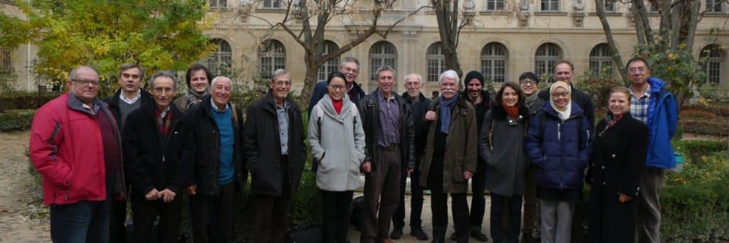
The first annual workshop was held in Paris, France, from 3 to 5 December 2018, and was organised by CCMG and Ecole Normale Supérieure. A group of 25 representatives from the People's Republic of China, Malaysia, Iran, Russia, Venezuela, Germany, Turkey, France, as well as scientists from Taiwan and Hong Kong universities. The workshop focused on designing the way of working and the division of labour, as well as the formation of the legend. There were lively scientific discussions. Discussions also focused on funding possibilities, deliverables and future meetings. A slot was dedicated to the digital dissemination of the final product and openings to generate cross-sections through a multi-layer model.
A brief history of the project was presented as well as several examples of available global reconstructions carried out in the past (of which there are not that many).
An unfinished but very useful attempt at a similar map was made by TOTAL some years ago, which highlighted the difficulties and proposed a legend. Parts of this map may be useful for the project.
The discussions then focused on the definition of an orogen; precisely what the general characteristics and differences are. There were various presentations highlighting the duration of the orogens, how erosion is responsible for the clearing of the upper parts and exhumes the deep and often metamorphosed crustal units; thus implying the need to modify the legend as one goes back in time.
The way in which the sutures should be represented was discussed, bearing in mind that they are expressed by small areas of the globe. However, they may be more important if the whole oceanic assemblage is included, including the mafic/ultramafic and oceanic sedimentary series. Examples have been shown in Turkey for the Alpine system and in Western Europe for the Variscan orogen.
The time frame was discussed by noting that some orogenic cycles may be very short (6 Ma in West Papua), or very long as in the Lower Palaeozoic, and that these may in fact include several short-lived events such as those observed in the Western Pacific or the Caribbean. There is a diachronism in the formation of mountain ranges as a function of the width of the subducted oceanic domain and the distance from the Euler pole. This reflects the well-documented diachronism in the recent opening of V-shaped marginal basins (Southeast Asia) and to some extent in the large ocean basins (Atlantic Ocean). This discussion led us to 2 important aspects for the legend.
1 - Diachronism; leads to a variation in the age of the basin closure; hence the suture, which can be so important in the case of large basins (Tethys, Palaeo-Tethys...) that they can merge like the Indosinian/Cimmerian orogen and the Upper Variscan. It has been proposed not to use these names and to follow the colour code of the International Commission on Stratigraphy (ICS)
2 - 'V' basins invoke the existence of a propagator that marks the transition in basin time and structure from a basin that developed oceanic spreading and an aborted graben lacking oceanic crust. This illustrates that 'intra-continental' and 'collisional' orogens can originate from the same basins with crustal variation along strike.
The discussion of temporality led to the importance in the project of the change in crustal construction or 'consolidation' before and after plate tectonics sensu stricto; a boundary that can be placed around 2.5 billion years. This could be well illustrated in the first cratonic part of the continents. We agreed to try to represent it on the cratonic part of the map with a different and less eye-catching look. In the current discussions, the legend would imply different types of orogen: (i) subduction orogen including ophiolites, metamorphism, magmatism and accretionary wedge, (ii) collisional orogen including metamorphism, syn-collisional magmatism, molasse basin, nappes and (iii) compression or intracontinental orogen. Consideration will also be given to ancient orogens where plate tectonics has not
exist. Going back in time, the main elements may have been simplified due to lack of data, misunderstanding, or heavy erosion, which uncovered the upper layers of the orogen.
Large parts of the map such as the Central Asian region are already well mapped and the type of data is not too difficult to adapt to the map project. The latter region appears complex on a map representation, but this could reflect the "South-East Asia" type of arc-continent collision and an intelligent legend could take into account such an orogen type as a "subduction type" or a "marginal basin shortening" type of orogen.
An attempt can be made to include the case of the Cordilleras in this box.
The map is in fact a very good candidate as a base map for a metamorphic map of the world. It could be a layer of the mapping project and the metamorphic facies could be represented as a complete circle on each orogen. Important magma bodies can be represented on the map. There was a discussion on the relevance of separating syn-tectonic and post-tectonic, which often have the same meaning or cannot be distinguished.
The successor basins actually have a similar significance in front of the developing mountain ranges and behind the orogens on the upper plate.
The layered representation of each orogen has multiple advantages;
1 - It allows simple reading without complicated cross-hatching "like a pyjama".
2 - It allows to represent and highlight the reactivation of orogens, which are a key to understand their location
3 - It allows the representation of large areas of diffuse deformation such as the area encompassed by the India-Eurasia collision
Active tectonics can be a separate representation to locate current deformation zones. It does not need to be as detailed as the forthcoming CGMW world seismotectonic map.
We discovered that there was potential for collaboration with IGCP662. We contacted Dr WangTao; PI of IGCP662; to explore the possibility of a joint workshop in the future. Some IGCP667 members are already involved in this project.
We decided to organise a splinter meeting and a poster meeting at the EGU in Vienna in April 2018
We discussed the possibility of having a session at IGC 35 in New Delhi in 2020
We had discussions about cooperation with IUGS, GGN in the organisation of our 2012 field trip considered in a UNESCO GEOPARK
A time slot was dedicated to the digital dissemination of the final product and openings to generate cross-sections through a multi-layer model. An engineer from the VisioTerra development team came specifically to answer the group's questions about the feasibility of a rapid global application of the project's results (i.e. displaying the layers for each orogen). This was confirmed.
We also discussed the possibility of posting deep envelopes on VtWeb. This one is already operational. So we can represent the Moho as a surface and we will send the data (CRUST db) to VisioTerra. We also need to explore whether a lower/upper crust grid is available. The critical aspect of the project is to try to represent the wireframe of basic cross sections anywhere on the globe so that users can build their own geological sections and teach geoscience using this tool. This is under development and is already working on simple multi-layer surfaces.
It was decided to launch a forum on ResearchGate to collect different opinions on the definition around the world.
We will then write an outline of an 'Episodes' article on the outcome of the discussion on the definition and major characteristics of an orogen.
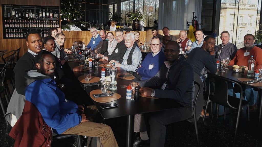
2019 - TERVUREN (BELGIUM) - 10 to 12 December 2019
This meeting included two days of meetings/conferences focusing on Africa and Europe
orogens and ancient cratons in collaboration with the Royal Museum for Central Africa, which is a major player in geological investigations in Africa. After a first version of the world map had already been produced (including the main orogens of the different continents with their respective ages and a detailed legend), the main objective of this meeting was to focus and finalise the design of the African continent and to present a sketch of the map in the other regions of the world.
This meeting also included a day trip to the Meuse Valley in the Belgian Brabant Massif, which has a major unconformity between the Caledonian (Cambrian to Silurian) and the Variscan (Devonian to Carboniferous) orogens.
should also include a day trip to the Meuse Valley in Belgian Brabant
Massif, which presents a major unconformity between the Caledonian (Cambrian to Silurian)
and the Variscan orogens (Devonian to Carboniferous).
Day 1 - Tuesday, 10 December (Royal Museum for Central Africa, ME Building, new entrancebuilding through room 3, level -1, see map below)
8.15am: Departure from Montgomery station - (see map below)
9h00-9h30: Manuel PUBELLIER (CGMW, ENS, CNRS, Paris), Christian ROBERT (ENS, Paris), Nadine ELLOUZ (IFP, Paris), Romain BOUSQUET (University of Kiel), Camille FRANCOIS (CCGM, Paris): Introduction, programme of the meetings, History and prospective of the project, Presentation of the beginnings of the art of the map, What is an orogen? Some definitions and conventions adopted at the last meeting...
9.30-10.00: Coffee break
10:00-12:30: Scientific presentations (15min/participant)
Camille FRANÇOIS: How to represent ancient geodynamics on the world map of orogens?
Joseph-Martial AKAME (Université Libre de Bruxelles) : Strain partitioning in a long-lasting Archaeological transpression in the Nyabizan greenstone belt, NW Congo craton (southern Congo) Cameroon)
Jean-Paul LIEGEOIS (Royal Museum for Central Africa, Tervuren) : Nature and meaning of the Pan-African orogeny; completion of the mapping of the Tuareg orogen (central Sahara).
Damien DELVAUX (Royal Museum for Central Africa, Tervuren): Kibarian in the Great Lake Region
Blaise KABAMBA BALUDIKAY (University of Kinshasa): The influence of the Kibaran orogeny of the Mbuji-Mayi Mesoproterozoic Supergroup deposit (DRCongo)
12.30-14.00: Lunch (Tembo restaurant, same building, first floor, free for all registered participants)
14h00-17h00: Scientific presentations :
Igor POSPELOV (VSEGEI): Tectonics of Central and North Asia
Ender SARIFAKIOGLU (Cankiri Karatekin University): Pontides of affected northern Turkey by the Variscan and Cimmerian orogenies.
Jeroen SMITT (University of Utrecht): The Thor Suture Zone: From Early Paleozoic Subduction the development of the Mesozoic intraplate basin
Jean-Paul LIEGEOIS (Royal Museum for Central Africa, Tervuren) : Brabant and the Ardennes Massive (Belgian Avalonia): behaviour of two contrasting bases with similar sediments sequences during the Cambrian rifting, Caledonian and Variscan orogenies; relationship with Gondwana.
Matthieu GALVEZ (ETH, Zürich): links between geodynamic structures and climate/carbon cycle
Cédric BULOIS (Université Nice Sophia-Antipolis) :Active normal fault along the compressional margin of the Santa Elena Peninsula region (Ecuador): inheritance process of extensional contexts related to active orogens
19.00: Dinner at the Brussels Centre (venue to be confirmed)
Day 2 - Wednesday, 11 December (Royal Museum for Central Africa, ME Building, new entrance building through room 3, level -1, see map below)
8.45am: Departure from Montgomery station
9:30-10:00: Define regional/orogeny/geological age working groups for the map
10.00-10.30: Coffee break
10:30-10:45: (to be confirmed) DA SILVA Anne-Christine (University of Liège): Presentation Projects: IGCP-652: Geological Time Reading in Paleozoic Sedimentary Rocks: The Need forintegrated stratigraphy & IGCP-580: Application of magnetic susceptibility to sediments of the Paleozoic.
10.45-12.30: work on the Map
12.30-14.00: Lunch (Tembo restaurant, same building, first floor, free for all registered participants)
14:00-15:30: work on the Map
15.30-17.00: Visit to the Museum of Mineralogy (Florias MEES)
19.00: Dinner at the Brussels Centre (venue to be confirmed))
Day 3 - Thursday, 12 December: Meuse Valley Field trip (by Damien DELVAUX & Daniel BAUDET)
8.00 am: Departure from Brussels-Montgomery station
17 registered participants (Manu, Bruno, Christian, Philippe, Nadine, Camille, Romain, Daniel, Igor, Roli, Damien, Thierry, Ender, Blaise, Cédric, Vinciane, Joseph-Martial)
STOPS (to be confirmed):
Stop 1 : Discordance at Tournavaux (Roche à Corpias)
Stop 2 : Bogny-sur-Meuse, rock of the 4 Fils Aymond : asymmetrical boudinage at Devillian quartzites, slate cleavage in the Revinan slates (Cambrian)
Stop 3 : Revin : foliation in black slate from the Revinian period
Stop 4: Fepin Discord
Stop 5 : Waulsortian reefs at Freyr
Stop 6 : Anseremme / Bayard rock
Stop 7 : Profondeville Syncline
Stop 8 : Citadelle of Namur (D. Baudet)
Stop 9 : Maredsous
Return to Brussels
The first annual workshop was held in Paris, France, from 3 to 5 December 2018, and was organised by CCMG and Ecole Normale Supérieure. A group of 25 representatives from the People's Republic of China, Malaysia, Iran, Russia, Venezuela, Germany, Turkey, France, as well as scientists from Taiwan and Hong Kong universities. The workshop focused on designing the way of working and the division of labour, as well as the formation of the legend. There were lively scientific discussions. Discussions also focused on funding possibilities, deliverables and future meetings. A slot was dedicated to the digital dissemination of the final product and openings to generate cross-sections through a multi-layer model.
A brief history of the project was presented as well as several examples of available global reconstructions carried out in the past (of which there are not that many).
An unfinished but very useful attempt at a similar map was made by TOTAL some years ago, which highlighted the difficulties and proposed a legend. Parts of this map may be useful for the project.
The discussions then focused on the definition of an orogen; precisely what the general characteristics and differences are. There were various presentations highlighting the duration of the orogens, how erosion is responsible for the clearing of the upper parts and exhumes the deep and often metamorphosed crustal units; thus implying the need to modify the legend as one goes back in time.
The way in which the sutures should be represented was discussed, bearing in mind that they are expressed by small areas of the globe. However, they may be more important if the whole oceanic assemblage is included, including the mafic/ultramafic and oceanic sedimentary series. Examples have been shown in Turkey for the Alpine system and in Western Europe for the Variscan orogen.
The time frame was discussed by noting that some orogenic cycles may be very short (6 Ma in West Papua), or very long as in the Lower Palaeozoic, and that these may in fact include several short-lived events such as those observed in the Western Pacific or the Caribbean. There is a diachronism in the formation of mountain ranges as a function of the width of the subducted oceanic domain and the distance from the Euler pole. This reflects the well-documented diachronism in the recent opening of V-shaped marginal basins (Southeast Asia) and to some extent in the large ocean basins (Atlantic Ocean). This discussion led us to 2 important aspects for the legend.
1 - Diachronism; leads to a variation in the age of the basin closure; hence the suture, which can be so important in the case of large basins (Tethys, Palaeo-Tethys...) that they can merge like the Indosinian/Cimmerian orogen and the Upper Variscan. It has been proposed not to use these names and to follow the colour code of the International Commission on Stratigraphy (ICS)
2 - 'V' basins invoke the existence of a propagator that marks the transition in basin time and structure from a basin that developed oceanic spreading and an aborted graben lacking oceanic crust. This illustrates that 'intra-continental' and 'collisional' orogens can originate from the same basins with crustal variation along strike.
The discussion of temporality led to the importance in the project of the change in crustal construction or 'consolidation' before and after plate tectonics sensu stricto; a boundary that can be placed around 2.5 billion years. This could be well illustrated in the first cratonic part of the continents. We agreed to try to represent it on the cratonic part of the map with a different and less eye-catching look. In the current discussions, the legend would imply different types of orogen: (i) subduction orogen including ophiolites, metamorphism, magmatism and accretionary wedge, (ii) collisional orogen including metamorphism, syn-collisional magmatism, molasse basin, nappes and (iii) compression or intracontinental orogen. Consideration will also be given to ancient orogens where plate tectonics has not
exist. Going back in time, the main elements may have been simplified due to lack of data, misunderstanding, or heavy erosion, which uncovered the upper layers of the orogen.
Large parts of the map such as the Central Asian region are already well mapped and the type of data is not too difficult to adapt to the map project. The latter region appears complex on a map representation, but this could reflect the "South-East Asia" type of arc-continent collision and an intelligent legend could take into account such an orogen type as a "subduction type" or a "marginal basin shortening" type of orogen.
An attempt can be made to include the case of the Cordilleras in this box.
The map is in fact a very good candidate as a base map for a metamorphic map of the world. It could be a layer of the mapping project and the metamorphic facies could be represented as a complete circle on each orogen. Important magma bodies can be represented on the map. There was a discussion on the relevance of separating syn-tectonic and post-tectonic, which often have the same meaning or cannot be distinguished.
The successor basins actually have a similar significance in front of the developing mountain ranges and behind the orogens on the upper plate.
The layered representation of each orogen has multiple advantages;
1 - It allows simple reading without complicated cross-hatching "like a pyjama".
2 - It allows to represent and highlight the reactivation of orogens, which are a key to understand their location
3 - It allows the representation of large areas of diffuse deformation such as the area encompassed by the India-Eurasia collision
Active tectonics can be a separate representation to locate current deformation zones. It does not need to be as detailed as the forthcoming CGMW world seismotectonic map.
We discovered that there was potential for collaboration with IGCP662. We contacted Dr WangTao; PI of IGCP662; to explore the possibility of a joint workshop in the future. Some IGCP667 members are already involved in this project.
We decided to organise a splinter meeting and a poster meeting at the EGU in Vienna in April 2018
We discussed the possibility of having a session at IGC 35 in New Delhi in 2020
We had discussions about cooperation with IUGS, GGN in the organisation of our 2012 field trip considered in a UNESCO GEOPARK
A time slot was dedicated to the digital dissemination of the final product and openings to generate cross-sections through a multi-layer model. An engineer from the VisioTerra development team came specifically to answer the group's questions about the feasibility of a rapid global application of the project's results (i.e. displaying the layers for each orogen). This was confirmed.
We also discussed the possibility of posting deep envelopes on VtWeb. This one is already operational. So we can represent the Moho as a surface and we will send the data (CRUST db) to VisioTerra. We also need to explore whether a lower/upper crust grid is available. The critical aspect of the project is to try to represent the wireframe of basic cross sections anywhere on the globe so that users can build their own geological sections and teach geoscience using this tool. This is under development and is already working on simple multi-layer surfaces.
It was decided to launch a forum on ResearchGate to collect different opinions on the definition around the world.
We will then write an outline of an 'Episodes' article on the outcome of the discussion on the definition and major characteristics of an orogen.