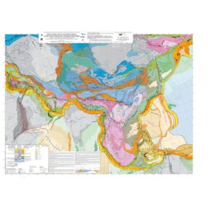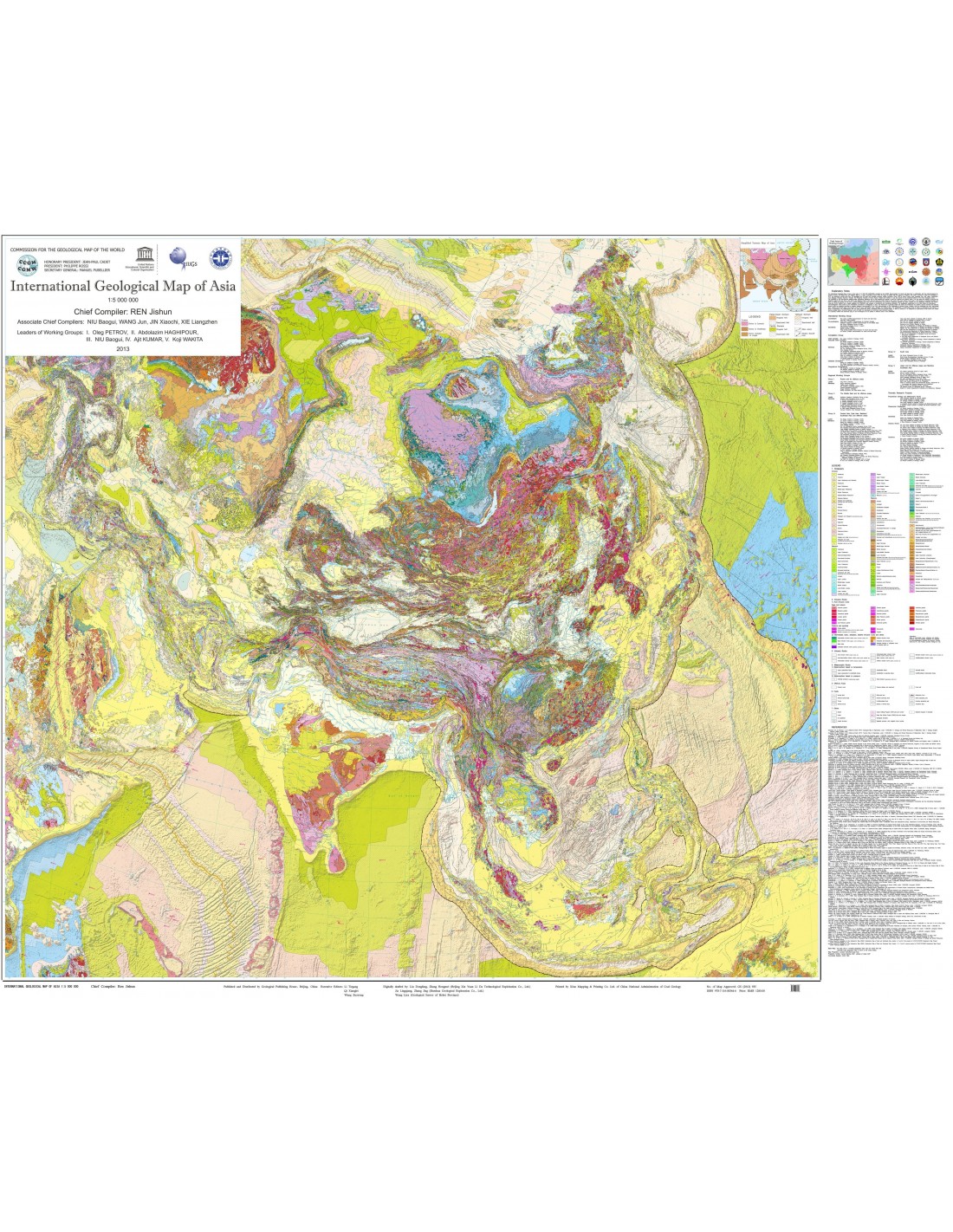

International Geological Map of Asia at 1:5 M
126,00 €
International Geological Map of Asia at 1:5 M
1rst edition 2013
Scale: 1:5,000,000
Projection : Lambert Azimuthal Equal Area, Central Meridian E90°, lat. origin N40°
Dimensions: 12 sheets, each measuring 100 x 69 cm
Authors: REN Jishun. Co-authors: NIU Baogui, WANG Jun, JIN Xiaochi, XIE Liangzhen
Working group chiefs: I. Oleg PETROV, II. Abdolazim HAGHIPOUR, III. NIU Baogui, IV. Ajit KUMAR, V. K. WAKITA
Availability: In stock
Description
International Geological Map of Asia at 1:5 M
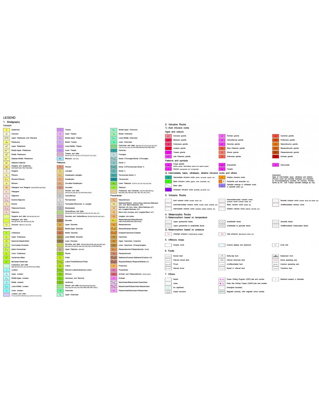
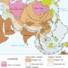
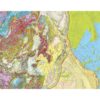
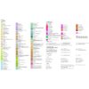
The International Geological Map of Asia (IGMA5000) is the first compilation at this scale to be produced using digital techniques. It shows the geology of the continental and oceanic regions of the entire Asian continent and its neighbouring regions, stretching from the Alps in the west to the Mariana Trench at its eastern end, and from the Arctic Ocean in the north to the Java Trough in the south. This document provides essential information for those wishing to familiarise themselves with the geology of Asia from a global perspective, as well as being a very useful tool for understanding the relationship between the tectonics of the Asian continent and that of the surrounding continents and oceans.
Some of the important advances taken into account in the compilation of the map are briefly summarised below.
1) A large number of Mesozoic volcanic formations found in the coastal zones of eastern Asia are now mainly attributed to the Cretaceous, instead of the Upper Jurassic-Lower Cretaceous. In Central Asia, most of the Permo-Carboniferous volcanic formations do not appear to be the result of arc volcanism, but of extensional dynamics. The lower Meso-Neoproterozoic limit of the Jixian section in China, previously dated at 1.8 Ga, has been rejuvenated to -1.68 Ga.
2) The most significant Neoarchean thermo-tectonic events in the Sino-Corean and Indian cratons occurred at 2.5 Ga rather than 2.7 Ga. The basement of the Yangtze craton formed at 0.75-0.8 Ga, i.e. 0.2-0.3 Ga after the Grenville orogenic cycle. Geologically, it has been determined that South China corresponds to a Lower Paleozoic Caledonian folded belt.
The Qinling belt, where no oceanic basin formed in the Triassic period, is not an Indosinian collision orogen, but is due to subduction of continental crust. At the time of the formation of Pangea, the Indo-Australian part of the supercontinent Gondwana was united with Paleo-Asia and consequently there was no ocean basin between these two blocks (no Paleo-Tethys from the Paleozoic to the Mesozoic). A large Indosinian orogenic belt existed in the southern margin of Palaeo-Asia, north of the present Zagros-Himalayas complex.
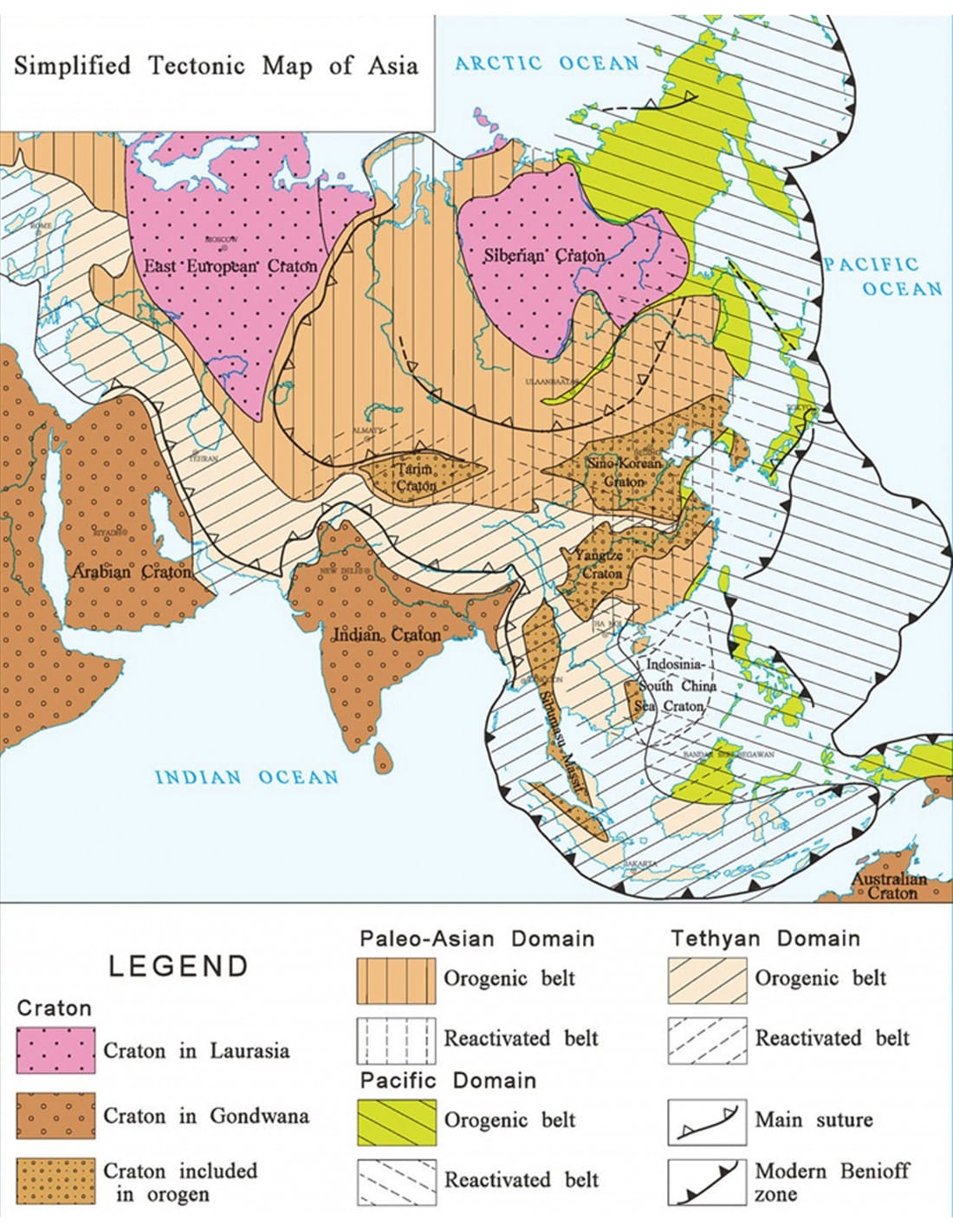
3) Asia is a composite continent consisting of three major cratons - Siberian, Indian and Arabian - and three major orogenic belts containing a number of minor cratons and micro-continents. Much of the Asian continent took its present form during the Mesozoic. The orogenic belts fall within three global tectonic domains: PalaeoAsia, Tethysian and Pacific.
Minor cratons such as the Sino-Korean, Yangtze, Tarim and Sibumasu can be considered to be linked to a transform tectonic zone between Gondwana and Siberia. Originally located in the northern margin of Gondwana before the disappearance of the Palaeo-Asian Ocean, these cratons, after the closure of the Palaeo-Asian Ocean and then the opening of the Tethys, found themselves on the southern margin of Palaeo-Asia. The fact that the age of the ophiolites in Asia decreases progressively from north to south suggests that, during the Phanerozoic, the separation of Gondwana and the accretion of Asia were accompanied by the southward migration of the latter's orogenic belts.
It was Academician Ren Jishun, from the Institute of Geology of the Academy of Geological Sciences in Beijing, who proposed the creation of the International Geological Map of Asia (IGMA) at the General Assembly of the CGMW in Paris in 2002. His proposal was endorsed by the CGMW Bureau and adopted by the 2004 General Assembly in Florence at the 32nd International Geological Congress.
Work on the IGMA 5000 began in 2005 under the aegis of the CCMG and with the support of UNESCO. The Sub-Commission of the CCMG for South and East Asia, whose Chairman is Prof. REN Jishun, took the lead in its realisation, with the collaboration of the Sub-Commissions of the CCMG for the Middle East, North Eurasia and Ocean Floor Maps, and the participation of the geological institutions and services of the participating countries, namely: Cambodia, China, France, India, Indonesia, Iran, Iraq, Japan, Kazakhstan, Laos, Malaysia, Myanmar, Mongolia, North Korea, Pakistan, Philippines, Russia, South Korea, Thailand and Vietnam.
The project received technical and financial support from the Geological Survey of China, Sinopec Exploration and China National Petroleum Corporation.
Six working groups were set up to carry out this extensive mapping synthesis, which involved six international workshops held in Beijing between 2005 and 2012. The geographical distribution of the working groups and the institutions that made them up are as follows
- Group I Northern Eurasia. The CCMG Sub-Commission for Northern Eurasia and the All-Russia Geological Research Institute (VSEGEI) were responsible for the geological compilation of Russia, Central Asia and the oceanic areas of the countries concerned;
- Group II China, Mongolia and the Korean Peninsula. The CCMG Sub-Commission for South and East Asia, the Geological Survey of China, the Institute of Geosciences and Mineral Resources of South Korea (KIGAM) and the Institute of Geology and Mineral Resources of the Mongolian Academy of Sciences.
- Group II Middle East. The Middle East Sub-Commission of the CGMW was responsible for the compilation of the geological map of the Middle and Near East, the surrounding areas in Africa and the ocean regions.
- Group IV Japan and Southeast Asia. The CCMG Sub-Commission for South and East Asia and the Geological Survey of Japan were responsible for the geological map of Japan, South-East Asia and the oceanic regions of the countries concerned.
- Group V South Asia. The CGMW Sub-Commission for South and East Asia and the Geological Survey of India were responsible for the geological map of South Asia and the surrounding ocean regions.
- Group VI Drafting Committee which was responsible for synthesising all the data provided by the five working groups.
THIS CARD IS ONLY AVAILABLE IN FOLDED FORMAT
International Geological Map of Asia at 1:5 M
Additional information
| Weight | 1,75 kg |
|---|---|
| Dimensions | 37 × 25 × 6 cm |
| Packaging | |
| Length | |
| Width | |
| Thickness | |
| Weight | |
| Scale |