As part of our commitment to the environment, we are changing our hosting provider to one that is more environmentally friendly. The site is currently being prepared for this transition.
Due to the summer break, the online shop will reopen on 15 August. Orders will be temporarily suspended until then.
Thank you for your patience and support.
We look forward to seeing you soon with an even more ethical and efficient site!
Due to the summer break, the online shop will reopen on 15 August. Orders will be temporarily suspended until then.
Thank you for your patience and support.
We look forward to seeing you soon with an even more ethical and efficient site!

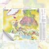
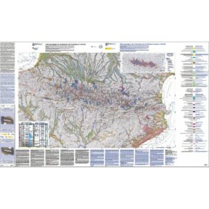
International geological map of Europe at 1:10 M
10,50 €
International geological map of Europe
2nd edition
Scale: 1:10 000 000
Map coordinator: Dr Kristine Asch
Projection: Lambert conic conformal
Format: 64.5 x 84.5 cm
International geological map of Europe
Description
International geological map of Europe
The 1:5 Million International Geological Map of Europe and adjacent areas (code name: IGME 5000; title and legend in English) was published at the end of 2005 and has been available since the beginning of 2006.
International geological map of Europe
It was produced by the BGR (German Federal Geological Survey) under the coordination of Kristine Asch, as part of the Commission for the Geological Map of the World (CGMW). It is the result of cooperation between 48 geological surveys and a network of scientific experts. This version at a scale of 1:10,000,000 is a reduction of the original scale and includes the same data.
This document replaces the International Geological Map of Europe and the Mediterranean Region published (in French) in 1971, also in Hanover, at the same scale and with an identical projection (Lambert conic conformal).
This new version is more extensive to the north and west, covering much of the North Atlantic, Greenland, and the European Arctic (Barents Sea) and West Siberian (Kara Sea) continental shelves; to the south, it extends from the Canary Islands and southern Morocco to the bottom of the Persian Gulf. It thus includes all the inland seas: the Mediterranean, the Black Sea and the Caspian.
The major novelty of this publication is that the geological information is no longer limited to the land area, but now extends to the entire seabed, which represents almost 60 % of the map surface. It is important to note that the entire map has been generated in digital form and that this work is supported by a combination of geoscientific and spatial data.
For the land areas, it is a traditional geological mapping, i.e. based on the age of the formation of the outcropping or subcropping rocks, and articulated on the three main classical domains: sedimentary rocks, "igneous" rocks, metamorphic rocks.
The age of the sedimentary deposits is given by the colour palette (and the corresponding indices) of the 49 chronostratigraphic caissons which range from the Archean to the Holocene; the Proterozoic being subdivided into three units (Paleo-, Meso-, Neoproterozoic).
The magmatic formations have been differentiated into intrusive and extrusive rocks, and each of these two categories is characterised by a set of 4 specific colours corresponding to 4 major chronological groups: Cenozoic (with differentiated Quaternary for the extrusive formations), Mesozoic, Paleozoic, Precambrian; their age being specified by one of the 49 indices mentioned above.
The metamorphism is represented, schematically and superimposed on the age of the protolith, by figures that indicate the degree of metamorphism: weak, medium, strong, undifferentiated.
A particular effort has been made, as mentioned, on the geology of the seabed, which falls into three major structural domains: the passive continental margin, the oceanic basin and the Mediterranean complex zone.
Continental shelves have been mapped using the same principles as on land whenever possible, i.e. over more than 2/3 of the corresponding surfaces. This is particularly enlightening for the major north-western European platforms: Bay of Biscay, English Channel, North Sea, Baltic, Arctic zone, etc. Otherwise, the continental margins have been mapped more schematically.
The major basaltic outpourings that followed the opening of the North Atlantic at the beginning of the Cenozoic are well mapped, in particular the Seaward-Dipping Reflector Series along the Greenland margin on one side and the British Isles and Norway on the other.
For the North Atlantic Basin, a classic example of an expanding ocean, the age of the original oceanic basaltic crust has been plotted, with the same hues as those of the contemporary Meso-Cenozoic deposits mapped on land. The axes of the magnetic anomalies were also plotted, as well as the ocean/continent transition zone.
International geological map of Europe
The cartography of the Mediterranean Sea and its annexes has benefited from recent advances in the knowledge of this very complex area where, in a general context of compression between Africa/Arabia and Eurasia, subductions, island arcs, continental crust stretching and associated submarine volcanic peaks, collisions, tectonic expulsion (of the Anatolian block), sedimentary accretion prisms, neoformation of the Anatolian block, etc., co-exist, continental crust stretching and associated submarine volcanic peaks, collisions, tectonic expulsion (from the Anatolian block), sedimentary accretion prisms, Neogene oceanic crust neoformation (Algerian-Provençal and Tyrrhenian back-arc basins), Mesozoic residues of the Tethysian ocean s.l. (Eastern Mediterranean, Black Sea, South Caspian Basin).
The extent of the Messinian salt deposits was also mapped.
For the subsea section, simplified GEBCO bathymetry (-100 m, -200 m, -500 m, then every 1000 m) and the position of the DSDP/ODP deep ocean drillings are also provided.
International geological map of Europe
The databases collected during the preparation of the model for the printing of this map have made it possible to produce a GIS (lithology and chronostratigraphy/geochronology), the conditions of availability of which will be decided at a later date by the RMO.
For more information: http://www.bgr.de/karten/IGME5000/IGME5000.htm
International geological map of Europe
Informations complémentaires
| Weight | 0,07 kg |
|---|---|
| Packaging | Tube (e.g. rolled card), Envelope (e.g. folded card or booklet) |
| Length | |
| Width | |
| Weight | |
| Scale |