As part of our commitment to the environment, we are changing our hosting provider to one that is more environmentally friendly. The site is currently being prepared for this transition.
Due to the summer break, the online shop will reopen on 15 August. Orders will be temporarily suspended until then.
Thank you for your patience and support.
We look forward to seeing you soon with an even more ethical and efficient site!
Due to the summer break, the online shop will reopen on 15 August. Orders will be temporarily suspended until then.
Thank you for your patience and support.
We look forward to seeing you soon with an even more ethical and efficient site!
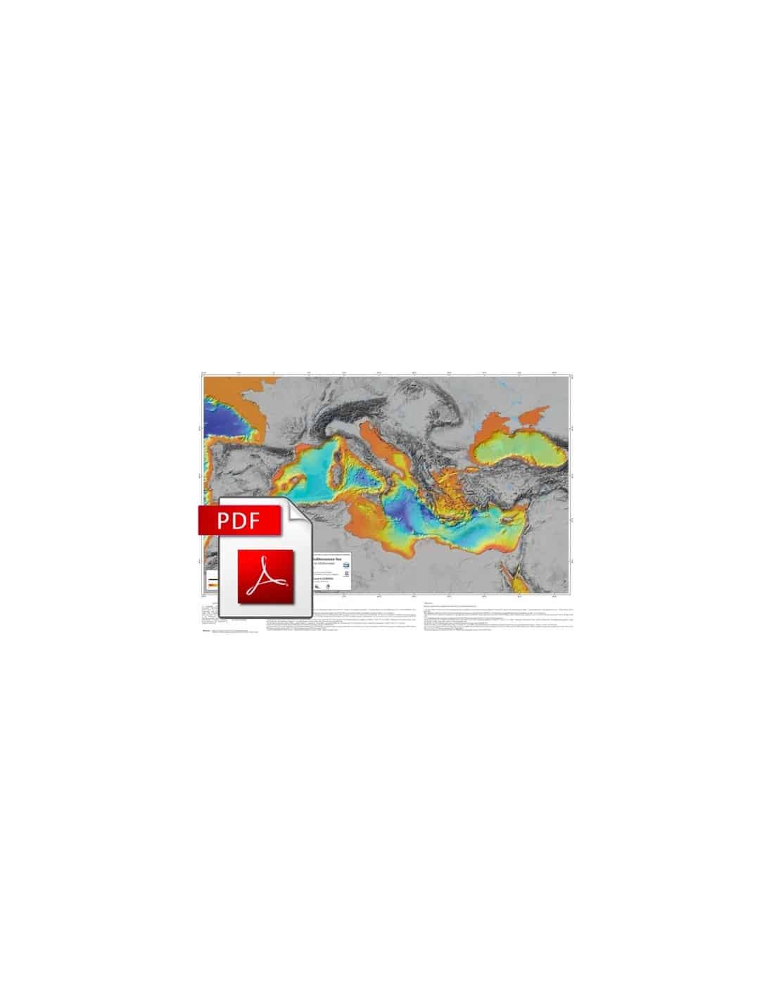
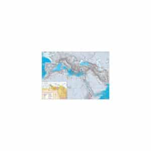
Morpho-Bathymetric Map of the Mediterranean - PDF
53,00 €
Morpho-Bathymetric Map of the Mediterranean - PDF
Scale 1:4,000,000
Total surface area: 119 x 85 cm
CCMG © 2012
Authors: Laëtitia Brosolo, Jean Mascle, Benoît Loubrieu
Description
Morpho-Bathymetric Map of the Mediterranean - PDF
Scanned version in high resolution .pdf format, sent by download link.
Note This card is subject to a licence agreement.
This map is also available in digital .pdf format in our catalogue.
This synthesis provides a global picture of the morphology of the Mediterranean domain and its continental environment, from the Gulf of Cadiz to the eastern shores of the Mediterranean and the Black Sea.
The Morpho-Bathymetric Map of the Mediterranean-PDF follows a previous morpho-bathymetric synthesis of the Mediterranean published jointly in 2008 by CIESM and IFREMER. For the elaboration of this new document, the 500m DTM, extracted from multibeam bathymetric data, has been completed by :
(1) Unpublished data from various sources including IFREMER, SHOM, GEOAZUR laboratory, OGS-Trieste, ISMAR-Bologna, CMCR-Hamburg, and locally (Nile Delta platform) by first arrivals of 3D seismic of oil origin
(2) A bathymetric compilation of the Gulf of Cadiz published by Zitellini, Gracia, et al;
(3) Some additional data from the web portal of the European EMODNET project;
(4) In the Black Sea, multibeam bathymetric data from the East European Craton (EEC) Assemblages project.
The 500 m DTM was combined with a 1500 m DTM from the General Bathymetric Chart of the Oceans (GEBCO) Atlas to illustrate the morphology of the entire Mediterranean. A 90 m DTM, extracted from SRTM 33'' (Shuttle Radar Topography Mission, NASA) provides the topography of the surrounding continental domains.
This document offers an image where the continental relief (in shades of grey) contrasts perfectly with the morphological shape of the Mediterranean, which is reproduced in an appropriate range of colours. This map is completed by a Geological and Morpho-tectonic Map of the Mediterranean Area, at the same scale (Authors: Jean Mascle and Georges Mascle).