
Tectonic map of Africa
16,00 €
Tectonic map of Africa
Scale 1:10,000,000 at the Equator
Published in November 2010
Mercator projection. Datum: WGS84
Central meridian: 20°E
Total surface area: 127 x 106 cm
Legend in English
Availability: In stock
Description
Tectonic map of Africa
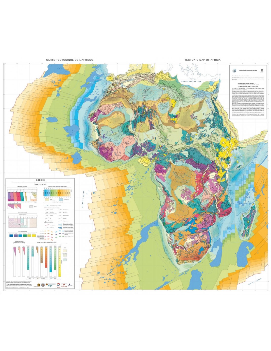
The first edition of the Tectonic Map of Africa dates from 1968, before the paradigm of plate tectonics was fully developed and accepted. The second edition of the 1/10 million scale Tectonic Map of Africa is the result of a quarter of a century of collaboration by a large number of scientists from European and African geological surveys and universities, supported in their efforts by two French companies, Total and Areva.
This new edition therefore takes account of the most recent developments in the Earth sciences, with the availability of ever more abundant and precise radiometric dating of Archean and Proterozoic formations, and in-depth knowledge of the structure of the major African sedimentary basins as a result of oil exploration.
Tectonic map of Africa
The major cartographic themes include :
The representation of successive orogenic systems: Archean, Eubnean-Paleoproterozoic, Kibaran-Mesoproterozoic, Pan-African-Neoproterozoic, Variscan-Cape Fold Belt, Atlas Alpine Orogen. An original method of representation also makes it possible to show the age of the reworking that the formations underwent during subsequent orogenic phases.
The major volcanic outpourings of post-Paleozoic times corresponding to hot spots: CAMP (Central Atlantic Magmatic Province), Karoo, Etendeka (linked to the Parana trapps in South America), Madagascar volcanism, Ethiopian trapps and volcanism linked to the Great East African Rift, as well as the other Cenozoic outpourings scattered across Africa. The "Younger granites" have also been included.
Particular attention has been paid to representing the major sedimentary basins that have developed from the Archean to the Cenozoic.
A particular colour is assigned to the age of initiation of the basin: Archean, Palaeoproterozoic, Mesoproterozoic, Neoproterozoic + Palaeozoic (in the south), Proterozoic (in the north), Cambrian-Ordovician, Silurian-Carboniferous, Carboniferous-Jurassic (Karoo), Meso-Cenozoic in which basins with maximum subsidence in the Jurassic, Cretaceous, and Cenozoic are distinguished.
In addition, with the exception of the Archean to Mesoproterozoic and Cambro-Ordovician basins, the other chronological units are represented with their isopaques. In addition, where the thickness of the Cenozoic (or Cretaceous to Cenozoic) cover of an older basin is less than 1,000 m, it is represented by a series of superimposed dots.
Tectonic map of Africa
For the continental margins of Africa, which are known to be important for hydrocarbon deposits, the approximate boundary between the continental crust and the oceanic crust and the isopaques (every 1,000 m) of the sedimentary fill have been represented.
The Niger Delta is a special case, with part of the onshore area built on Cretaceous oceanic crust and a sedimentary accumulation of over 10 km.
In conclusion, this map represents a major advance in the representation of tectonic and structural knowledge of the African continent, both in terms of the mass of innovative data it synthesises and the highly original representation method it requires.
It will therefore be of great interest to both professional geologists (oil exploration, basement studies, geodynamics) and university lecturers and their students.
Tectonic map of Africa
Additional information
| Weight | 0,19 kg |
|---|---|
| Packaging | Tube (e.g. rolled card), Envelope (e.g. folded card or booklet) |
| Length | |
| Width | |
| Weight | |
| Scale |


