
World map of groundwater resources
5,25 €
World map of groundwater resources
Scale: 1/40,000,000
Dimensions: 104 x 84 cm
Card only available folded
©BRG Hannover / UNESCO Paris, 2008
Map prepared as part of the WHYMAP programme (World-wide Hydrogeological Mapping and Assessment Program)
Availability: In stock
Description
World map of groundwater resources
WHYMAP is a programme developed by a consortium comprising the United Nations Educational, Scientific and Cultural Organization (UNESCO), the Commission for the Geological Map of the World (CGMW), the International Association of Hydrogeologists (IAH), the International Atomic Energy Agency (IAEA) and the German Federal Institute for Geosciences and Natural Resources (BGR), with the collaboration of a large number of experts from different regions of the world.
The aim of the programme is to collect, assemble and visualise hydrogeological data on a global scale. The aim of the project is to transmit information on groundwater in a relevant form to contribute to global discussions on the subject of water, and also to raise public awareness of resources that are not directly visible.
The products generated by the programme are the result of compilations of groundwater data from national, regional and global sources. They provide quantitative, qualitative and vulnerability information on the world's groundwater resources.
World map of groundwater resources
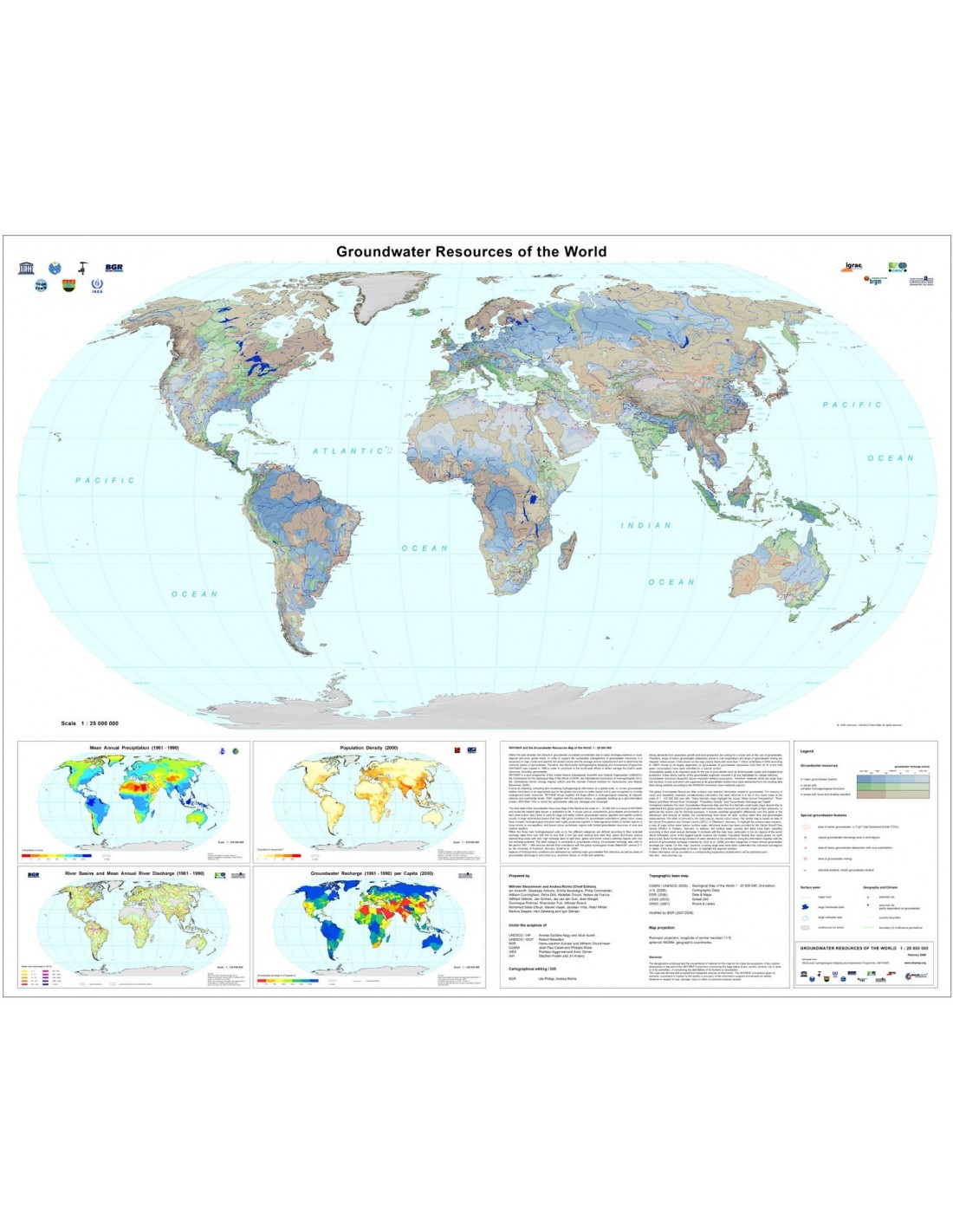
This 1:40,000,000 map of the world's groundwater resources is one of the results of the WHYMAP project. It summarises all the data relating to the project known or published to date, and presents various characteristic groundwater environments in their regional context:
- the colour blue is used to represent extensive and fairly uniform basins containing groundwater (aquifers and aquifer systems usually within large sedimentary basins which may have conditions favourable to the exploitation of groundwater)
- the green areas have a complex hydrogeological structure (with highly productive aquifers in heterogeneous folded or faulted regions and in close proximity to non-aquiferous areas)
- and finally, the brown areas correspond to regions with groundwater resources limited to local shallow aquifers.
The global map of groundwater resources shows only information relating to groundwater. For clarity and legibility, important additional information has been represented on four 1:1 20,000,000 maps located at the bottom left of the main map. These maps cover: average annual rainfall; the basins of the main rivers and their average annual discharge; population density and groundwater recharge per capita.
See also: www.whymap.org
Map prepared by : Wilhelm Struckmeier and Andrea Richts (Editors) with the collaboration of : lan Acworth, Giuseppe Arduino, Emilia Bocanegra, Philip Commander, William Cunningham, Petra Dôll, Abdallah Droubi, Nelson da Franca, Wilfried Gilbrich, Jan Girman, Jac van der Gun, Jean Margat, Dominique Poitrinal, Shaminder Puri, Alfonso Rivera, Mohamed Safar-Zitoun, Siavek Vasak, Jaroslav Vrba, Peter Winter, Markus Zaepke, Han Zaisheng and Igor Zektser.
World map of groundwater resources
Informations complémentaires
| Weight | 0,1 kg |
|---|---|
| Packaging | |
| Length | |
| Width | |
| Weight | |
| Scale |


