

Geological map of the Bosumtwi Impact Crater
10,50 €
Geological map of the Bosumtwi Impact Crater
Scale: 1:50,000
Card size: 86 x 61 cm
Only available folded - instructions in English
Published in the supplement of the Annual Bulletin 2005 of the Geological Survey of Austria
Geological Survey of Austria (2005)
Topography© 1972 by the Survey Department, Ministry of Lands and Mineral Resources of Ghana
Availability: In stock
Description
Geological map of the Bosumtwi Impact Crater
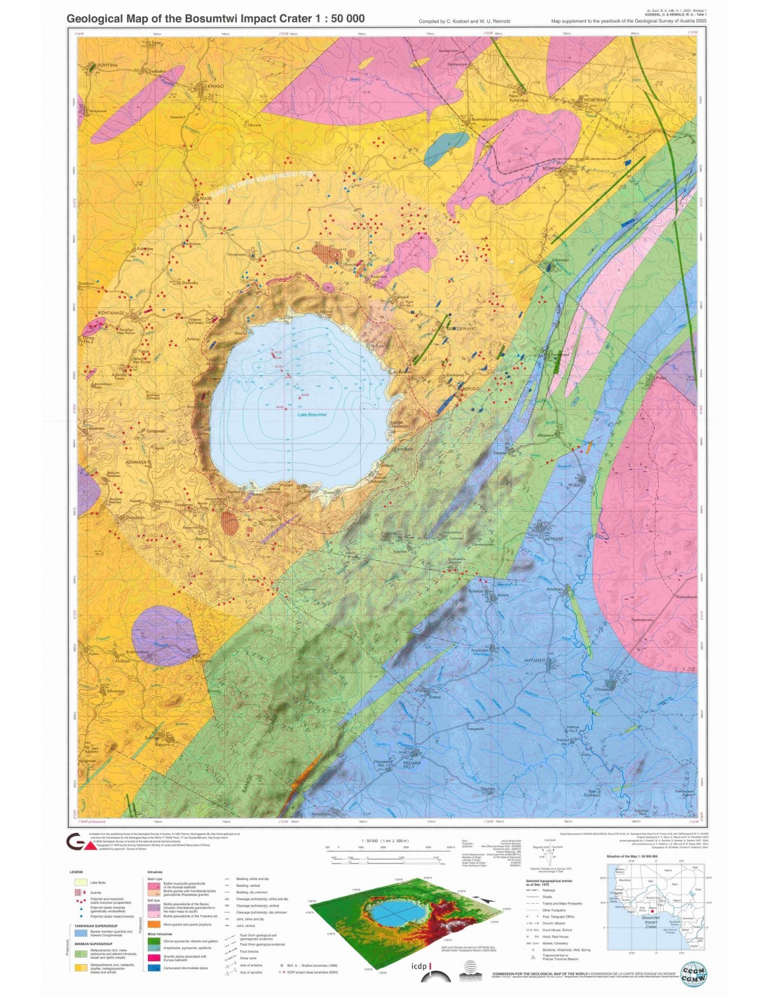
The Geological map of the Bosumtwi Impact Crater presents one of the best-preserved and best-studied recent meteorite impact craters. It was compiled by Christian Koeberls (University of Vienna, Austria) and Wolf Uwe Reimold (University of the Witwatersrand, Johannesburg, South Africa). This publication by the Austrian Geological Survey is accompanied by a 40-page booklet with a series of colour illustrations.
The Bosumtwi impact crater is located in the Ashanti province in the forest zone of southern Ghana (06°30' N and 01°25' W), in West Africa. Formed in Precambrian meta-sedimentary and meta-volcanic rocks 2.1-2.2 billion years old, Bosumtwi is a very well preserved impact crater, 10.5 km in diameter and dated at 1.07 Ma.
The crater, marked by a fairly pronounced rim, is almost entirely filled by Lake Bosumtwi (diameter 8.5 km), which reaches a depth of 78 m in its central part. It is one of the 19 confirmed African impact craters and is associated with the Côte d'Ivoire tectite field, one of only four currently known in the world.
The characteristics of Lake Bosumtwi give it a certain importance, as it is able to provide detailed information on climate change in the equatorial region. The lake, whose deep waters are anoxic, has developed in a closed hydrological basin, which has enabled the lake's sedimentary sheets (varves) to be preserved, providing a favourable environment for high-resolution (annual) palaeoclimatic reconstructions.
Geological map of the Bosumtwi Impact Crater
Because of its importance for impact crater geology and palaeoclimatology, Bosumtwi has recently been the focus of interdisciplinary and multi-national studies as part of the International Continental Scientific Drilling Program (ICDP).
Since the mid-1990s, renewed interest in Bosumtwi has led to multinational teams studying the geology, geophysics, petrology, geochemistry and sediments of its impact crater, its associated impact breccias and its geological structure. Remote sensing and geophysical measurements (gravity, magnetism, seismic-reflection and refraction) have provided a wealth of data on the crater and its subsurface.
However, the only comprehensive regional mapping around Bosumtwi dates back to the 1960s and consisted of a map (in two sheets) of the geology around the lake. The aim of our work is therefore to present a unified geological map with updates and new data that highlight impact-induced deformation and the known distribution of impact breccia.
Geological map of the Bosumtwi Impact Crater
Informations complémentaires
| Weight | 0,21 kg |
|---|---|
| Packaging | |
| Length | |
| Width | |
| Weight | |
| Scale |


