A new look for our website! 🌱
As part of our commitment to the environment, we are in the process of switching to a more environmentally-friendly hosting provider. The site is currently being prepared for this transition.
Orders are temporarily suspended while the migration is finalised.
Thank you for your patience and support.
We look forward to seeing you soon with an even more ethical and efficient site!
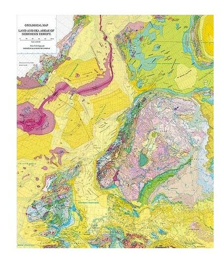
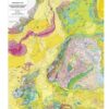
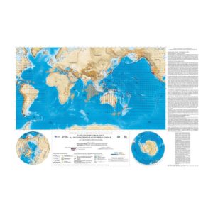
Geological map of the oceanic and continental regions of Northern Europe
21,00 €
Geological map of the oceanic and continental regions of Northern Europe
Scale: 1:4 000 000
Published in 2002 by the Geological Survey of Norway
1 sheet size: 140 cm x 100 cm
In English and Norwegian. Explanatory notes in English.
Main coordinator :
Dr. Ellen M.O. Sigmond (NGU)
NGU, 2002
Geological map of the oceanic and continental regions of Northern Europe
Description
Geological map of the oceanic and continental regions of Northern Europe
The Norwegian Geological Survey (NGU), in cooperation with the geological surveys of 22 European countries, has mapped the pre-Quaternary basement of northern Europe at a scale of 1:4 million.
For the first time until 2002, the geology of the continental and oceanic formations of the regions is presented as a whole. The area covered extends longitudinally from eastern Greenland to New Zealand and latitudinally from Svalbard to the northeast of the French coast; the western part of the Russian shelf is also included.
The geology includes rocks of all ages from Archean gneisses to recent mid-Atlantic ridge basalts, except for Quaternary sediments. In addition to the basement geology, fault zones, escarpments, accretionary axes, magnetic anomalies and continental-oceanic crustal boundaries have been represented. Fourteen cross-sections were included, as well as profiles of deep borehole sites in the oceanic zones.
The countries that participated in its realization are :
Belgium, Czech Republic, Denmark, Estonia, Finland, France, Germany, Iceland, Ireland, Latvia, Lithuania, Luxembourg, Netherlands, Norway, Poland, Russia, Slovakia, Sweden, Ukraine, United Kingdom and Northern Ireland.
This mapping project was financially supported by the Norwegian Geological Survey and the following oil companies: Amerada Hess Norge A/S, Mobil Exploration Norway Inc, Norsk Agip A/S, Norsk Hydro ASA, Phillips Petroleum Company Norway, Saga Petroleum a.s. (now Norsk Hydro ASA) and Statoil ASA.
The printed edition of the map has been published in two languages, Norwegian and English. A digital version is also available on the Norwegian Geological Survey website: www.ngu.no.
Geological map of the oceanic and continental regions of Northern Europe
Informations complémentaires
| Weight | 0,535 kg |
|---|---|
| Packaging | Tube (e.g. rolled card), Envelope (e.g. folded card or booklet) |
| Length | |
| Width | |
| Weight | |
| Scale |