A new look for our website! 🌱
As part of our commitment to the environment, we are in the process of switching to a more environmentally-friendly hosting provider. The site is currently being prepared for this transition.
Orders are temporarily suspended while the migration is finalised.
Thank you for your patience and support.
We look forward to seeing you soon with an even more ethical and efficient site!


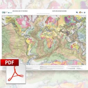
1/5 M geological map of the world - PDF
200,00 €
1/5 M geological map of the world - PDF
1st edition 2024
Main map projection: Mercator
Scale: 1:5,000,000 (at the equator)
Authors : Benjamin Sautter, Manuel Pubellier, Yang Song, Wu Zhenhan (CAGS)
Scanned version in PDF format, sent by download link. The PDF file for this map cannot be edited.
The map, once printed in AO format (84.1 cm high), will have a scale of 1/35M at the equator, as well as projections of the poles.
Please note This file is the first version (v0) of the map. We encourage users to contribute to its improvement by submitting their comments or suggestions via the following link: World5M Contributions. The purchase of this first version will also enable you to benefit from the new version free of charge when the next version is published. All you have to do is send us a written request to the following address ccgm@sfr.fr as soon as you are aware of the publication of v1 (this information will be available on our website).
Description
1/5 M geological map of the world - PDF
Note: This map is subject to a licence agreement.
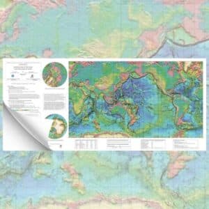
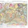
The need and urgency for the global Earth science community to have a digital geological map of the world is considerable, as it does not exist on a practical working scale. The World 5M project aims to establish a correlation between global continental geological maps and ocean structural maps, all of which are digital.
It is jointly supported by CGMW, the IUGS Big Science Program DDE and the Chinese Academy of Geological Sciences (CAGS). The project involves the construction of a uniform and seamless 1/5M scale digital geological map of the world and its complete database (Figure 1), which could be used as a portal or entry point to access other Deep-time Digital Earth (DDE) geological data.
The World 5M integrates 8 continental geological maps and 4 oceanic structural maps at a scale 1:5M which have been produced under supervision of the Commission for the Geological Map of the World (CGMW) over the past 20 years.
The main stages of the project involve establishing a legend and including specific metadata for the database, as well as harmonising stratigraphic transitions and correcting vector geometries at map boundaries. As part of a two-year initiative, high-resolution datasets of stratigraphy and geological structures have been integrated, guaranteeing the homogeneity of information on a global scale.
The map, which includes more than 180,000 polygons modelling the world's geology, is colour-coded according to the age of the rocks on the International Stratigraphic Scale, making geological analysis easier.
It should be noted that the drawing of the outer limits of continental margins may be imprecise and has no legal value under the United Nations Convention on the Law of the Sea (UNCLOS). The map uses the spherical Mercator projection for the main areas and the polar stereographic projection for the circumpolar regions.
Editing and design :
The layout and graphics were designed by Julie Tugend and Philippe Rossi.
References :
To quote this card, please use the following reference:
Sautter, B., Song, Y., Pubellier, M., Zhenhan, W. 1:5M Geological Map of the World, CCGM-CGMW, 2024.
ISBN : 978-2-917310-50-2
DOI : 10.14682/2024GEOWORLD5M
Sautter, B., Song, Y., Pubellier, M., Zhenhan, W., Yang, X., Li, W. (2022). The World 5M : Geological Map of the World at scale 1 :5M. © CGMW, CAGS, DDE