A new look for our website! 🌱
As part of our commitment to the environment, we are in the process of switching to a more environmentally-friendly hosting provider. The site is currently being prepared for this transition.
Orders are temporarily suspended while the migration is finalised.
Thank you for your patience and support.
We look forward to seeing you soon with an even more ethical and efficient site!
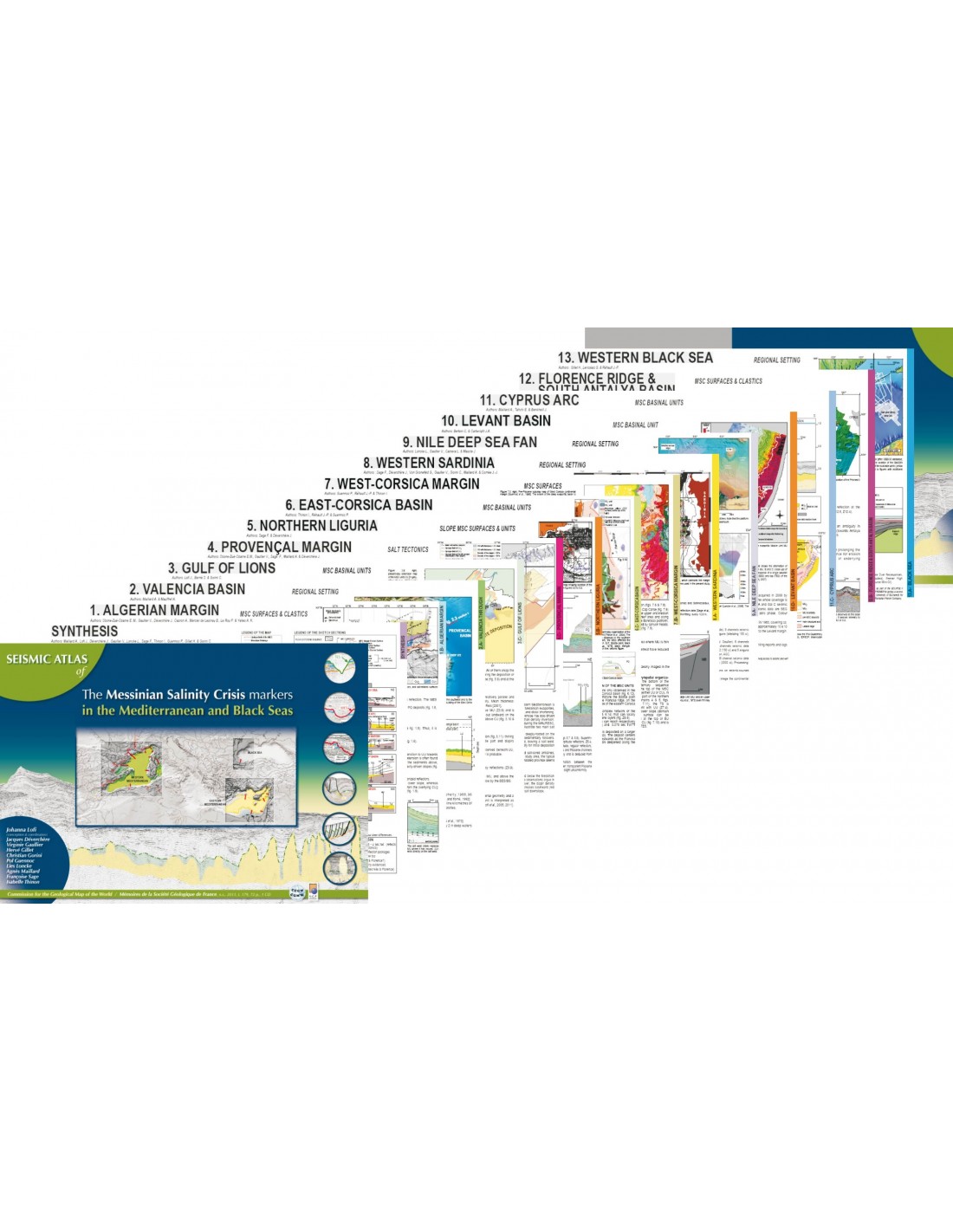


Seismic Atlas of the Messinian Salinity Crisis markers in the Mediterranean and Black Seas-Vol.1
16,00 €
Seismic Atlas of the Messinian Salinity Crisis markers in the Mediterranean and Black Seas-Vol.1
72 pages + CD
In English only
Geological Society of France & CCGM 2011
Authors: J. Lofi, J. Déverchère, V. Gaullier, H. Gillet, C. Gorini, P. Guennoc, L. Loncke, A. Maillard, F. Sage and I. Thinon
Description
Seismic Atlas of the Messinian Salinity Crisis markers in the Mediterranean and Black Seas-Vol.1
The Messinian Salinity Crisis (MSC) is a succession of extraordinary events that have profoundly altered the Mediterranean area in a very short period of time on a geological scale.
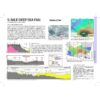
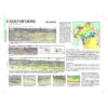
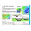
The book "Seismic Atlas of the Messinian Salinity Crisis markers in the Mediterranean and Black Seas-Vol.1"is the result of a collective effort to bring together in a single publication the most striking seismic features relating to this exceptional event. The seismic data was acquired during numerous offshore campaigns over the last few years. The 13 case studies selected describe the seismic facies, geometry and extension of Messinian markers (surface units and deposits).
The succession in absolute ages of Messinian events, or the processes at the origin of their occurrence in space and time, are not part of the topics discussed, the objective of this Atlas being to :
- to draw up a portrait of the Messinian markers from the most important margins and basins;
- propose a new global and consistent terminology for these markers for the entire Mediterranean marine area, and
- make these data accessible to the non-geophysical community.
Interpreted seismic data have been carefully selected according to their quality, location and significance to achieve these objectives and are presented in this Atlas.
COMPOSITION OF THE ATLAS
- 1 Explanatory note
- 1 summary of the organisation of the markers allowing for inter-site comparison.
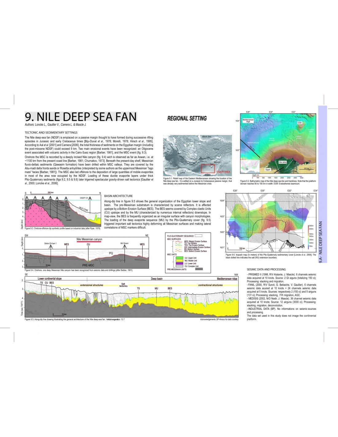
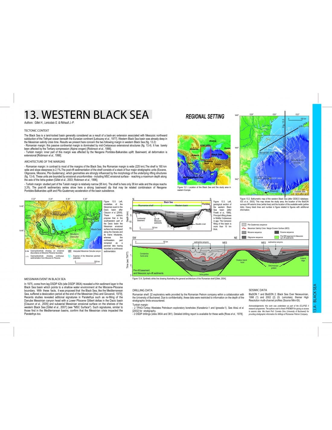
- 43 pages presenting the 13 areas studied according to the following themes: regional context, MSC surfaces, MSC basin units, and for some specific areas, detritus and/or salt tectonics
- 1 CD containing raw and interpreted seismic data
Seismic Atlas of the Messinian Salinity Crisis markers in the Mediterranean and Black Seas-Vol.1
13 SITES
The Atlas illustrates the study of the marginal segments and basins of the 13 areas with different structural, geodynamic and geological histories (e.g. intermediate/deep basin; with/without sill; active/passive margin; thin/thick sedimentary cover, etc.).
The Atlas allows for an integrated study on the scale of the Mediterranean basin. This new approach, based on comparative multi-site studies, paves the way for future discussions on the impact of the MSC and improved documentation of how the MSC has left its mark on the marine environment.
NOMENCLATURE AND COLOUR CODES
A new global terminology is proposed for the MSC markers (erosion surfaces and deposits). The terminology for deposits is based on their seismic facies and the geometric relationship of these units to the Mobile Unit (transparent facies and its associated plastic deformation). Surfaces were defined on the basis of their relationship to the Pre-MSC and MSC units, and the Plio-Quaternary cover.
Contributors :
J. Benkhelil, S. Berné, C. Bertoni, L. Camera, J.A. Cartwright, A. Capron, S. Dümmong, C. Hübscher, G. Lericolais, S. Leroy, J. Mascle, A. Mauffret, B. Mercier de Lépinay, E. M. Obone Zue Obame, J. P. Rehault, B. Savoye, N. Sellier, E. Tahchi, G. VOn Gronefeld, A. K. Yelles
Design and layout by Johanna Lofi
Seismic Atlas of the Messinian Salinity Crisis markers in the Mediterranean and Black Seas-Vol.1
Informations complémentaires
| Weight | 0,26 kg |
|---|---|
| Packaging | |
| Length | |
| Width | |
| Weight |