
Seismotectonic map of Africa-PDF
79,00 €
Seismotectonic map of Africa-PDF
1st edition (2016)
Scale: 1:15 000 000
Dimensions: 96 x 96 cm
Coordinator and compiling author: Mustapha Meghraoui (EOST - IPG Strasbourg, France)
(See below the list of co-authors and collaborators)
Availability: In stock
Description
Seismotectonic map of Africa-PDF
Scanned version in high resolution .pdf format, sent by download link.
Note This card is subject to a licence agreement.
This map is also available in digital .pdf format in our catalogue.
Seismotectonic map of Africa-PDF
This first edition of the Seismotectonic Map of Africa-PDF is the result of a multidisciplinary collaborative effort that involved drawing up scientific and technical specifications and setting up a working group with expertise in analysing existing data.
The project, which follows a proposal from the African Geological Surveys Organisation (OAGS), was carried out between 2011 and 2016 under the aegis of the Commission of the Geological Map of the World and with the support of the following institutions: UNESCO (Paris headquarters and Nairobi office) as Project 601 of the International Geoscience Programme (IGCP); NAGET (North African Group of Earthquake and Tsunami studies); the Global Earthquake Model (GEM Foundation); the International Union of Geological Sciences (IUGS) and the Geological Society of Africa.
The printed version of this first edition of the map was prepared and presented at the 35th International Geological Congress held in Cape Town, South Africa, from 27 August to 4 September 2016.
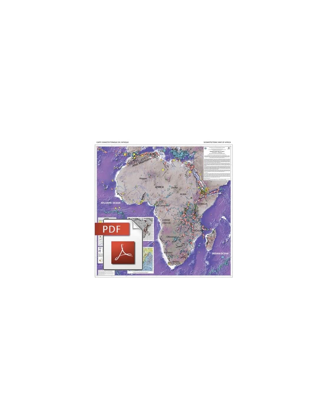
The printed version of the Seismotectonic Map of Africa-PDF is a synthesis at a scale of 1:10,000,000 based on regional maps (the Seismotectonic and Seismic Hazard Map of Tunisia is provided as a PDF file). here - click to download- as an example of these regional maps).
In particular, it shows the distribution of historical and instrumental earthquakes, neotectonic and quaternary faults, and two cartridges representing plate kinematics and velocity vectors on the one hand, and the map of the main tectonic stresses on the other.
The map is accompanied by explanatory notes (in English only) and can be downloaded here. More information and data on the 1:5,000,000 map are available on the website of the Strasbourg School and Observatory of Earth Sciences: http://eost.u-strasbg.fr/igcp601/Documents.html
The African continent comprises geological structures affected by zones of active deformation. Seismically active regions are mainly located along rift zones, folded and thrust belts, transform faults and volcanic fields.
Several tectonic structures can generate strong earthquakes that can cause major damage and affect the economy. The development of thematic mapping, with the identification and characterisation of active seismic zones, forms the basis for assessing seismic risks and defining disaster prevention measures.
Seismotectonic map of Africa-PDF
To accompany the preparation of this map, the aim was also to set up a database containing information on: historical and instrumental earthquakes, active tectonics, stress tensor distribution, earthquake geology, palaeoseismicity, active deformation and earthquake geodesy (GPS), crustal structure and seismic tomography, gravimetric, magnetic and structural segmentation, volcanic fields, rifting processes and geodynamic evolution.
A master plan for organising the preparation of the seismotectonic map, and the analysis of the related data, was drawn up beforehand to ensure the homogeneity of the results. Harmonisation (e.g. earthquake intensity and magnitude, fault parameters, etc.) at local, regional and continental levels was an important step in this process. Data collection and storage were organised using a geo-referencing process in GIS format.
Seismotectonic map of Africa-PDF
Authors and contributors:
Co-authorsPaulina Amponsah (GAEC, Accra, Ghana), Abdelhakim Ayadi (CRAAG, Algiers, Algeria), Atalay Ayele (Addis Ababa University, Ethiopia), Bekoa Ateba (IRGM, Yaoundé, Cameroon), Abdunnur Bensuleman (Tripoli Univ, Libya), Damien Delvaux (RMCA-Tervuren, Belgium), Mohamed El Gabry (NRIAG, Cairo, Egypt), Rui-Manuel Fernandes (UBI/IDL, Portugal), Vunganai Midzi & Magda Roos (Council for Geoscience (CSG), Pretoria, South Africa) and Youssef Timoulali (Univ. Mohamed V, Rabat, Morocco)
StaffMourad Bezzeghoud (University of Evora, Portugal), Joao Fonseca (Technical University of Lisbon, Portugal), Chris Hartnady (Umvoto, South Africa),
Ray Durrheim and Alain-Pierre Tokam Kamga (Wits University, South Africa), Nacer Jabour (CNRST Rabat, Morocco), Alaeddine Belfoul (University of Agadir, Morocco),
Abdelkader Soumaya (University of Tunis), Boniface Kankeu (IRGM, Yaoundé, Cameroon), Richard Ferdinand (University of Dar es Salaam, Tanzania), Hesham Hussein (NRIAG, Egypt),
Nada Ahmed (Sudan Geological Survey), Said Maouche and Assia Harbi, Farida Ousadou (CRAAG Algiers, Algeria), Eric Calais (ENS, Paris), Cécile Doubre (IPG Strasbourg),
Brassnavy Manzunzu and Thifhelimbilu Mulabisana (CGS, South Africa), Kwangwari Marimira (Goetz Obs, Zimbabwe), Gladys Kianji (University of Nairobi),
Bertrand Delouis (Géosciences Azur, Nice) and Rocco Malservisi (University of South Florida, USA).
Seismotectonic map of Africa-PDF
Reference of the article published in the journal Éepisodes of the IUGS :
Meghraoui, M., P. Amponsah, A. Ayadi, A. Ayele, B. Ateba, A. Bensuleman, D. Delvaux; M. El Gabry, R.-M. Fernandes, V. Midzi, M. Roos, Y. Timoulali, 2016, The Seismotectonic Map of Africa, Episodes Vol. 39, no. 1, DOI:10.18814/epiiugs/2016/v39i1/8923
Seismotectonic map of Africa-PDF


