Map of the Indian Ocean
10,50 €
Map of the Indian Ocean
Sheet 1 "Physiography",
Sheet 1: Physiography Sheet 2: Structure
Published in August 2004 at the original scale of 1:20 000 000
Reprinted at 1:40,000,000 scale in 2013
Sheet size: 59.4 cm x 42 78 cm each
CCMG
Financial support: UNESCO and IPEV (Institut Paul Emile Victor)
Authors: J. Ségoufin, M. Munschy, Ph. Bouysse and V. Mendel, et al.
Availability: In stock
Description
Map of the Indian Ocean
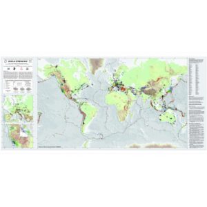
The two sheets (1- Physiography; 2- Structural Map) of this Map, were the first in a new series of maps of the CGMW dedicated to the world's oceans. The Indian Ocean map shows the main morphological and structural features of the region, and covers both the land and the seabed. It incorporates the most recent data from marine magnetic anomaly and satellite altimetry campaigns stored in international geophysical databases.
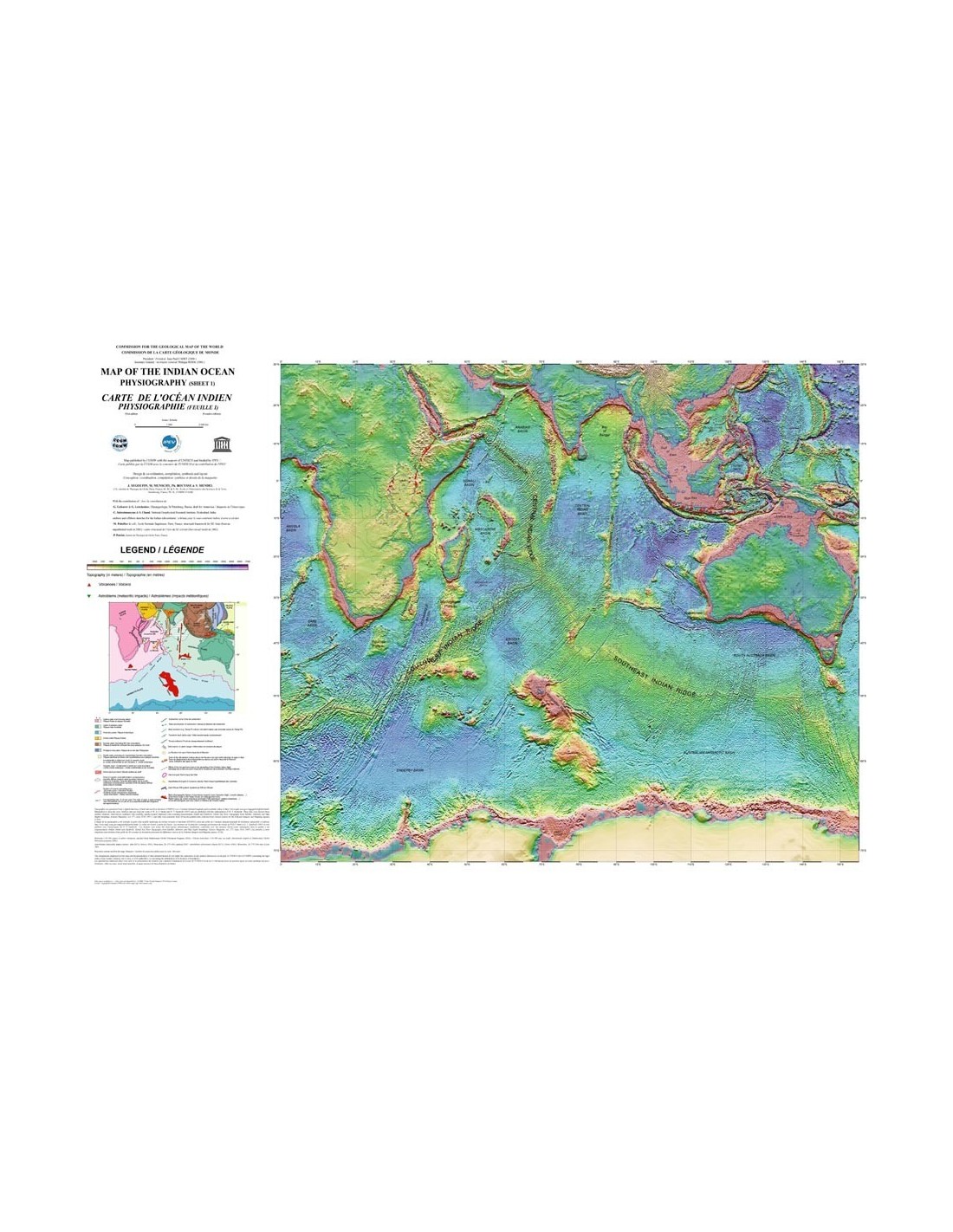
The Physiography map provides a digitised 'fine-grained' image of the morphology of the land and sea surfaces, supplemented by the drawing of selected isobath curves (-200 m, -1000 m, then every 1000 m). In addition to its scientific interest, the aesthetics of this sheet is undeniable. Some 300 active or Holocene volcanoes and about 40 meteorite impact craters are plotted.
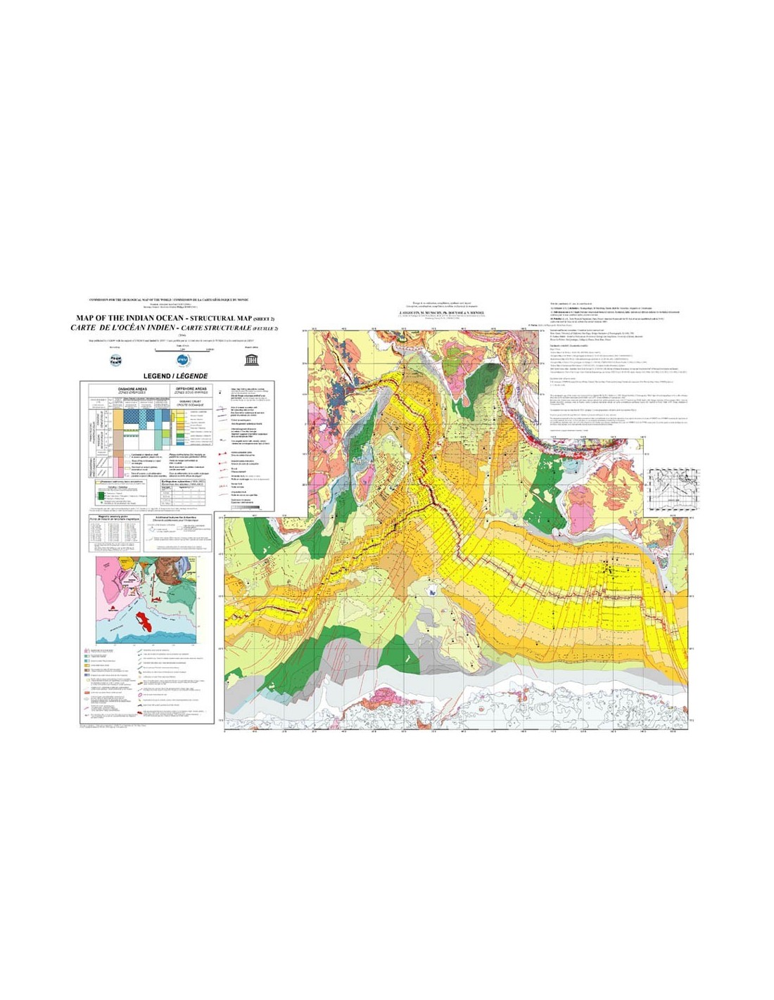
The most striking geological features are shown on land on the Structural Map: Archean, Proterozoic, Phanerozoic basins; Palaeozoic, Mesozoic, and Cenozoic orogenies; major accidents, large strike-slip faults, thrust fronts. Because of its specific environment (giant ice cap), Antarctica has received appropriate cartographic treatment. For submarine areas, the emphasis has been on the structuring of the oceanic crust: chronostratigraphic ages, oceanic accretion axes, transform faults, subduction zones, anomalous crustal reliefs (asismic ripples, oceanic plateaus, etc.).
Also shown are the locations of picks of standard magnetic anomalies (chron), divergence vectors (accretionary ridges) and convergence vectors (subduction zones), the thickness of sediments overlying the oceanic basement, and the compression zone affecting the oceanic crust between the Indian continental block and its Australian counterpart.
Map of the Indian Ocean
Earthquakes of magnitude = 5.0 have been plotted, both onshore and offshore, with a figure depending on their strength and depth at focus.
In the box, a geodynamic sketch summarises the main characteristics of plate tectonics in the mapped area; it highlights in particular the imprint of the Reunion hotspot on the lithosphere, which has been in motion since about 65 Ma, the time of the gigantic outpouring of basalts from the Deccan traps. After the original edition ran out, a reduced version of the two maps at a scale of 1:40 000 000 was published in October 2013.
Explanatory notes to download here
Map of the Indian Ocean
Informations complémentaires
| Weight | 0,08 kg |
|---|---|
| Dimensions | 59 × 42 × 0,1 cm |
| Packaging | Envelope (e.g. folded card or booklet), Short tube (e.g. small rolled card) |
| Length | |
| Width | |
| Weight | |
| Scale |