


World gravity map
27,00 €
World gravity map
Scale 1:50 000 000
Published in 2012
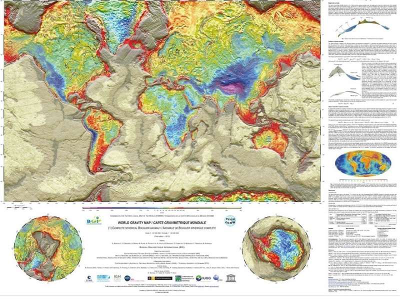
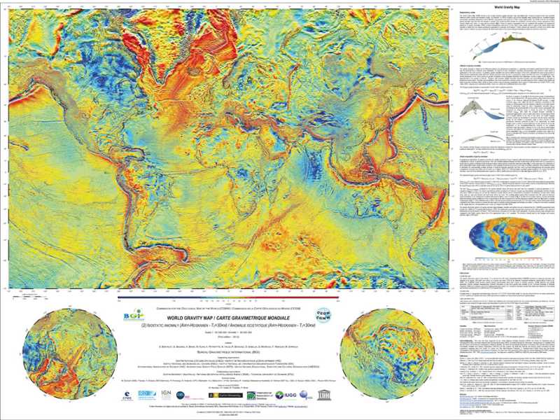
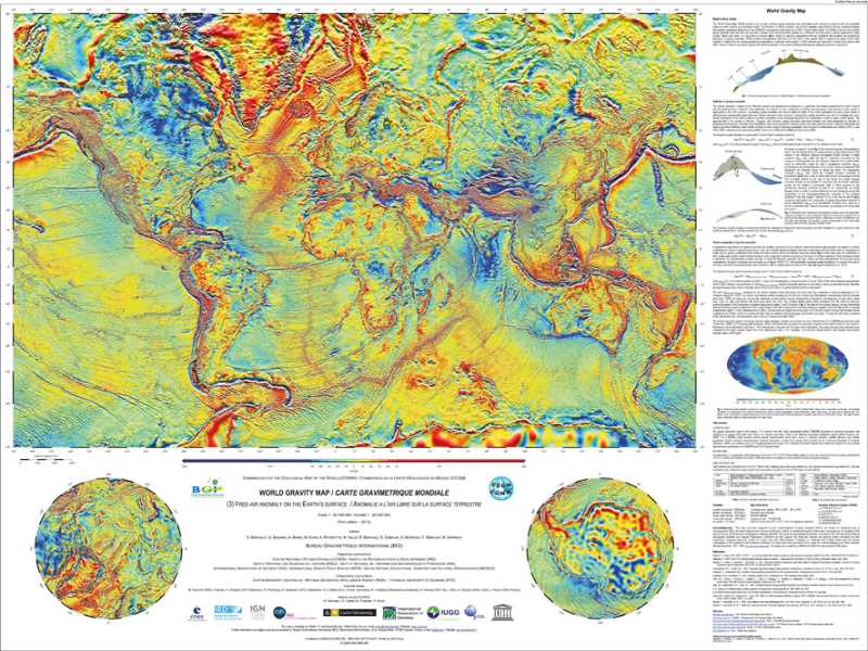
Sets of 3 cards: Bouguer anomalies, isostatic (Airy-Heiskanen), free air on earth surface
Size of each card: 105 x 82 cm
CCGM, BGI, CNES, IRD © 2012
Authors: S. Bonvalot, G. Balmino, A. Briais, M. Kuhn, A. Peyrefitte, N. Vales, R. Biancale, G. Gabalda, G. Moreaux, F. Reinquin and M. Sarrailh
Availability: In stock
Description
- World gravity map designates a set of 3 global maps of anomalies in the Earth's gravity field, calculated by the Bureau Gravimétrique International (BGI), a service of the International Association of Geodesy (IAG).
- This set of digital maps, produced for the Commission of the Geological Map of the World (CGMW), UNESCO, the International Union of Geodesy and Geophysics (IUGG) and the International Union of Geological Sciences (IUGS), represents the world's first spherically symmetric gravity anomaly maps based on a realistic Earth model.
- Calculated on the basis of available global gravity field models (EGM08, DTU10), the gravity anomalies presented here (Bouguer, Air-free, Isostatic) include high-resolution topographic corrections, taking into account the effect of masses related to continents, oceans, inland lakes and seas and ice caps. New theoretical developments have been carried out to enable high-resolution calculation on a global scale (Balmino, G., Vales, N., Bonvalot, S. and Briais, A., 2011. Spherical harmonic modeling to ultra-high degree of Bouguer and isostatic anomalies. Journal of Geodesy. DOI 10.1007/s00190-011-0533-4).
- Anomaly maps such as these, which reflect the density heterogeneities within the Earth (crust, mantle, etc.), are used in many applications in earth physics, structural geology and geodesy (shape of the Earth, geoid), as well as for the exploration of natural resources (mining and oil prospecting).
- Soon to be available in digital form, they are intended to be updated and disseminated for research and educational purposes.
- This project, led by the Bureau Gravimétrique International (BGI), is the result of a collaboration between various research institutes in different countries (France, Germany, Australia, Denmark, USA).
- The WGM2012 grids (2'x2′ resolution) and the explanatory leaflet in English are downloadable from the International Gravimetric Bureau (BGi) website : http://bgi.omp.obs-mip.fr/data-products/Grids-and-models/wgm2012
- World gravity map
Informations complémentaires
| Weight | 0,288 kg |
|---|---|
| Packaging | Tube (e.g. rolled card), Envelope (e.g. folded card or booklet) |
| Length | |
| Width | |
| Weight | |
| Scale |


