![Tectonic map of Antarctica - 2nd edition - PDF [TeMAnt]](https://ccgm.org/wp-content/uploads/2023/02/Carte-tectonique-de-lAntarctique-2eme-edition-PDF-TeMAnt.jpg)
![Tectonic map of Antarctica-2nd edition [TeMAnt] : Zen Cart!](https://ccgm.org/wp-content/uploads/2023/02/Carte-tectonique-de-lAntarctique-2eme-edition-TeMAnt.jpg)
![Tectonic map of Antarctica - 2nd edition - PDF [TeMAnt]](https://ccgm.org/wp-content/uploads/2023/02/Carte-tectonique-de-lAntarctique-2eme-edition-PDF-TeMAnt-100x100.jpg)
![Tectonic map of Antarctica-2nd edition [TeMAnt] : Zen Cart!](https://ccgm.org/wp-content/uploads/2023/02/Carte-tectonique-de-lAntarctique-2eme-edition-TeMAnt-100x100.jpg)
Tectonic Map of the Antarctic-2nd edition-PDF
79,00 €
Tectonic Map of the Antarctic-2nd edition-PDF [TeMAnt]
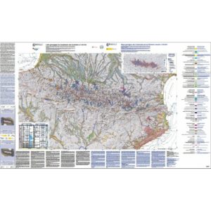
The map is based on a polar stereographic projection centered on the South Pole, with true scale latitude at 71°S. The datum is WGS 84. The Antarctic coastline on the main map and insets is approximated from the Antarctic Digital Database (ADD): http://www.add.scar.org:8080/add/
Digital pdf version, sent by download link.
Note: This card is subject to a licence agreement.
Tectonic Map of the Antarctic-2nd edition-PDF [TeMAnt]
Availability: In stock
Description
Tectonic Map of the Antarctic-2nd edition-PDF [TeMAnt]
The 1st edition of 1:10,000,000 Tectonic Map of the Antarctic was compiled as a CGMW contribution to IPY 2007-2009 scientific program and published in 2012. During the 2010-2020's a considerable progress was made in acquisition of geophysical information (mostly shipborne seismic and magnetic data in marine regions and airborne magnetic, gravity and radio-echo sounding data overland).
Marine gravity anomalies were derived from ERS altimetry observations over deep ocean floor, and extensive state-of-the-art analytical studies were performed on the collections of Antarctic rocks. These achievements enhanced insight in the structure and geodynamic history of the South Polar Region and stimulated preparation of the 2nd edition of the 1:10,000,000 Tectonic Map (TeMAnt).
- The ages of oceanic crust are refined based on revised identification of magnetic anomalies;
Major tectonic elements plausibly predicted under ice sheet by available remote sensing data are shown in an interpretative inset together with evaluation of seafloor spreading rates in the Southern Ocean;
- The map is accompanied by explanatory notes containing description and illustrations of major tectonic elements, as well as references to key data sources used for the compilation.
Advances of TeMAnt by comparison with the 1st edition are as follows: - The areas comprising subaerial bedrock exposures that had been mapped within the limits of credible interpolation are distinctly displayed on the main map against vast ice-covered terrain totally lacking ground-truth geological evidence. Sub-ice bedrock is only characterized by shadow relief seen through transparent ice sheet, while a clear color image of bedrock topography is provided in a separate inset illustrating morphostructural appearance of mapped tectonic features; - The ages of protolith emplacement, primary cratonization and subsequent reworking events are defined for most of the East Antarctic crystalline basement complexes; - Improved interpretation of polyphase magmatic arc history is proposed for the present-day Pacific margin; - A more accurate structural imaging is completed in Antarctica’s continental margin, including the positioning of marginal rifts, the location of continent-ocean boundary and the distribution of sediment thickness.
Acknowledgments: The systematic field activities in Antarctica carried out over the past decade by the Polar Marine Geosurvey Expedition (PMGE, St. tectonic structure of offshore regions. The free access to these data granted for the purposes of compiling TeMAnt is greatly appreciated. We thank Ju.B. Guseva for her contribution to the interpretation of marine data, and to A.V. Golynsky and D.A. Golynsky for using the database of the ongoing international BEDMAP project for the preparation of state-of-the-art images of the bedrock topography of the map area . Anonymous reviewers provided valuable feedback on the original draft, prompting some changes to the geological content of the map and the search for alternative layout options. Special thanks are due to the CCGM staff for their encouragement and continued support of the TeMAnt project.
Tectonic Map of the Antarctic-2nd edition-PDF [TeMAnt]
Informations complémentaires
| Packaging | Tube (e.g. rolled card), Envelope (e.g. folded card or booklet) |
|---|---|
| Length | |
| Width | |
| Weight | |
| Scale |