A new look for our website! 🌱
As part of our commitment to the environment, we are in the process of switching to a more environmentally-friendly hosting provider. The site is currently being prepared for this transition.
Orders are temporarily suspended while the migration is finalised.
Thank you for your patience and support.
We look forward to seeing you soon with an even more ethical and efficient site!

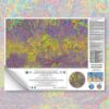
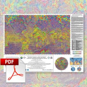
Magnetic Anomaly Map of the World
8,40 €
Magnetic Anomaly Map of the World
Equatorial scale: 1:50 000 000
Published in July 2007
1 sheet: 100 x 73.4 cm
CCGM-CGMW 2007
Authors: J.V. Korhonen,J. Derek Fairhead, M. Hamoudi, K. Hemant, V. Lesur, M. Mandea, S. Maus, M. Purucker, D. Ravat, T. Sazonova & E. Thébault
Printed by the Geological Survey of Finland
Description
Magnetic Anomaly Map of the World
This map is the first global compilation of the vast amount of data collected over the past 50 years from aeromagnetic surveys of land areas, magnetometry profiles recorded during sea campaigns to assess the age of the oceanic crust, and satellite observations.
The aim of this map is to help interpret surface observations of the Earth's geological composition and structure. Metamorphism, petrology and redox states have major effects on the magnetic state of the minerals that make up the material of the crust.
The magnetic anomalies shown on this map originate from the formation and composition of igneous and metamorphic rocks in the Earth's crust, probably in the upper part of the Earth's mantle, i.e. in the lithosphere.
What we call the magnetic anomaly field corresponds roughly to the lithospheric field, which represents the difference between the measured data, which includes all the magnetic sources, and the estimated core and external fields. This anomalous field is therefore created inside the magnetic lithosphere, but it is important to bear in mind that only structures with an amplitude of less than 2,500 km can be taken into account.
In almost all cases, the magnetic anomaly field represents less than 1% of the total magnetic field.
The study of crustal magnetism has contributed, among other things, to the development of geodynamic models of the lithosphere, geological mapping and natural resource exploration.
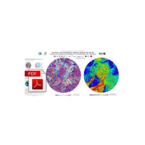
Magnetic Anomaly Map of the World
Earth magnetism map data such as the one presented here, in conjunction with other information, can be very useful in defining geological provinces, locating impact structures, dykes, faults and other geological formations with magnetic contrasts to their surroundings.
For this reason, the Magnetic Anomaly Map of the World is published in printed and digital form, together with a database on DVD. The magnetic field shown on the map corresponds to an altitude of 5 km above the WGS84 ellipsoid.
Two versions of the map (A and B), plus regional data and other databases and updates are available on the WDMAM project website: http://www.wdmam.org. It is version B that is represented in the printed map.
In version A, the near-surface data were not taken into account and were replaced by the downward-extended CHAMP magnetic field model. Version B, on the other hand, contains both data models derived from the CHAMP and marine ages, with priority given to the latter.
Both versions, when extended upwards to satellite altitude, reproduce the magnetic anomaly field derived from the "satellite field".
Magnetic Anomaly Map of the World
Informations complémentaires
| Weight | 0,115 kg |
|---|---|
| Packaging | Tube (e.g. rolled card), Envelope (e.g. folded card or booklet) |
| Length | |
| Width | |
| Weight | |
| Scale |