


Antarctica Pack
45,00 €
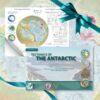
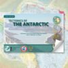
Antarctic Pack: Antarctic Map + Booklet
Pack containing Tectonic map of Antarctica, second edition and Explanatory notes to the "Tectonic map of Antarctica".second edition (English version)
Authors: Garrik Grikurov & German Leitchenkov
Publishers : CCGM-CGMW
Composition and design: C. François
Antarctica Pack
Availability: In stock
Description
Antarctica Pack: Tectonic map + Explanatory notes
Tectonic map of Antarctica - 2nd edition
The 1st edition of the 1:10,000,000 tectonic map of Antarcticapublished in 2012, was compiled as a contribution from the CGMW to the IPY 2007-2009 scientific programme. Over the period 2010-2020, considerable progress has been made in the acquisition of geophysical information (mainly seismic and magnetic data from ships in marine areas and airborne data from magnetic, gravity and radio echo soundings on land).
Marine gravity anomalies were derived from ERS altimetry observations over deep ocean floor, and extensive state-of-the-art analytical studies were performed on the collections of Antarctic rocks. These achievements enhanced insight in the structure and geodynamic history of the South Polar Region and stimulated preparation of the 2nd edition of the 1:10,000,000 Tectonic Map (TeMAnt).
- The ages of oceanic crust are refined based on revised identification of magnetic anomalies;
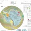
Major tectonic elements plausibly predicted under ice sheet by available remote sensing data are shown in an interpretative inset together with evaluation of seafloor spreading rates in the Southern Ocean;
- The map is accompanied by explanatory notes containing description and illustrations of major tectonic elements, as well as references to key data sources used for the compilation.
The advances made by TeMAnt compared to the 1st edition are as follows:
- Areas comprising sub-glacial bedrock outcrops that had been mapped within the limits of credible interpolation are clearly displayed on the main map against a vast ice-covered terrain totally devoid of ground-truth geological evidence. The subglacial bedrock is characterised only by shadow relief seen through the transparent ice cap, while a clear colour image of the bedrock topography is provided in a separate inset illustrating the morphostructural appearance of the map.
Tectonic features:
- The ages of protolith emplacement, primary cratonisation and subsequent reworking events are defined for most of the crystalline basement of the complex East Antarctic;
- A better interpretation of the history of the polyphase magmatic arc is proposed for the present-day Pacific margin;
- More precise structural imaging is being carried out on the Antarctic continental margin, including the positioning of marginal faults, the location of continent-ocean boundaries and the distribution of sediment thickness;
Tectonics of the Antarctic
The 1rst edition of Tectonic map of the Antarctic at 1:10 M scale was published by CGMW in 2012
Significant input of new data during the past decade stimulated upgrading of the 2012 map and preparation of the 2nd edition.
Design of the legend allows compact visual presentation of both geodynamic and age-related information. Map units are in the first place distinguished by the type of crust they represent, and by formation at plate boundaries or in within-plate settings.
Oceanic crust is mapped in accordance with the age of generation identified by magnetic anomalies. Archean complexes are grouped in a separate block of the legend believed to represent a primeval continental plutonic/metamorphic infrastructure (protocrust) lacking clear plate tectonics markers.
Proterozoic and Phanerozoic complexes are referred to either unstretched or stretched continental terranes.
Unstretched crust comprises accretionary fold belts (orogens), structural products of their reworking, platform covers and intraplate fold systems.
Stretched continental crust controls distribution of rift systems and associated sedimentary basins. A greater part of Antarctic continental margin belongs to a magma-rich type. Within lengthy zones contiguous to oceanic crust the continental crust is hyperstretched to the extent of unroofing the upper mantle.
Generalized view of Antarctic tectonic structures, including their inferred distribution under the ice sheet, is provided in a smaller-scale inset also showing the rates of sea-floor spreading and areas with thickened oceanic crust.
Antarctica Pack
Informations complémentaires
| Weight | 0,385 kg |
|---|


![Tectonic map of Antarctica - 2nd edition - PDF [TeMAnt]](https://ccgm.org/wp-content/uploads/2023/02/Carte-tectonique-de-lAntarctique-2eme-edition-PDF-TeMAnt.jpg.webp)


