
Structural map of the Atlantic Ocean
16,00 €
Structural map of the Atlantic Ocean
Equatorial scale: 1:20,000,000
Published in July 2012
1 sheet: 119 x 84 cm
CCGM-CGMW 2012
Author : Peter S. Miles (CCGM)
Co-authors: Philippe Bouysse (CCGM) and Kaiser de Souza (CPRM, Brazil)
Availability: In stock
Description
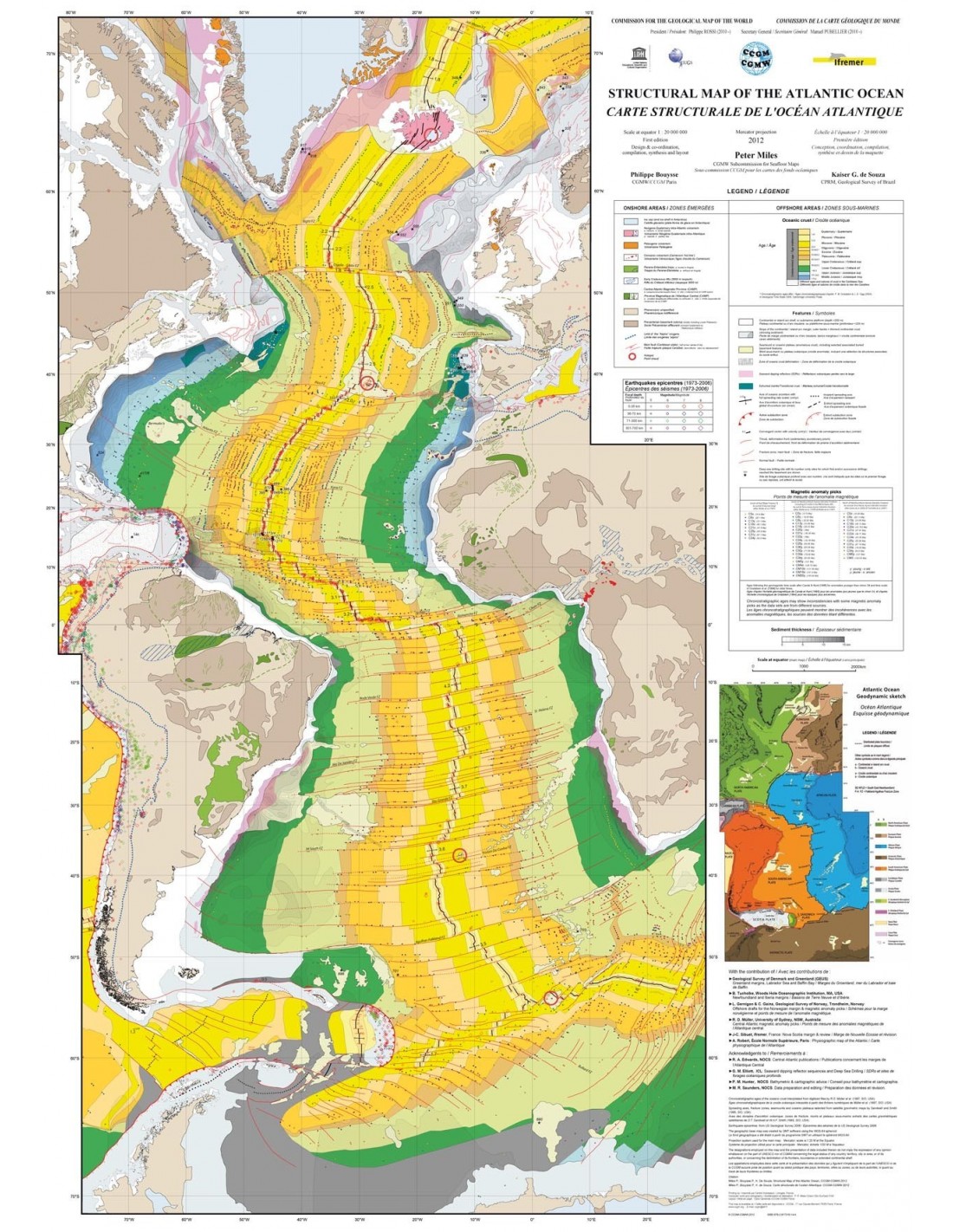
Structural map of the Atlantic Ocean
This map, covering the entire Atlantic Ocean, is being published for the 34th International Geological Congress (Brisbane, August 2012) and is an extension of the North Atlantic Structural Map (2008), which it replaces. It synthesises geological interpretations and geophysical data, spanning several decades, compiled from sea campaigns and the resulting publications.
The main, structural map shows the ocean and the surrounding continents with their simplified structural features. The following elements are represented in the oceanic domain:
- Age of oceanic crust, by epoch
- Positions of standard magnetic anomalies (or "chrone"), where they have been measured or interpreted
- Active and fossil oceanic expansion axes
- Transform faults and fracture zones
- Abnormal" submarine features and subduction zones
- Sequences of oceanic sloping reflectors (SDRs)
- Earthquake epicentre and depth of focus
- Hot spots
- Deep ocean drilling sites (DSDP, IPOD, ODP, IODP) where bedrock or transitional crust has been reached
- Thickness of sediments, with isopaques drawn on oceanic crust or on areas of thinned continental crust
- Oceanic crustal deformation zones
- Representation of continental geological features linked to the opening of the Atlantic Ocean
Structural map of the Atlantic Ocean
The structural map is accompanied by a geodynamic sketch (inset in the map and downloadable by clicking on here) and a Physiographic Map (inserted in the centre of the explanatory notes, which can be downloaded by clicking here). These two documents show the layout of the lithospheric plates that cover or enclose the Atlantic area, the morphology of the whole, and the place names of a number of underwater structures mentioned in the text.
The map was produced with financial support from UNESCO, the Norwegian Geological Survey (2008) and IFREMER (France).
Structural map of the Atlantic Ocean
Informations complémentaires
| Weight | 0,14 kg |
|---|---|
| Packaging | Tube (e.g. rolled card), Envelope (e.g. folded card or booklet) |
| Length | |
| Width | |
| Weight | |
| Scale |


